IMAGES TAKEN NEAR TO
Stagshaw, NEWCASTLE UPON TYNE, NE12 5BN
Introduction
This page details the photographs taken nearby to Stagshaw, NE12 5BN by members of the Geograph project.
The Geograph project started in 2005 with the aim of publishing, organising and preserving representative images for every square kilometre of Great Britain, Ireland and the Isle of Man.

There are currently over 7.5m images from over14,400 individuals and you can help contribute to the project by visiting https://www.geograph.org.uk
Image Map (Loading...)


Getting Data...Please wait
Leaflet Map data © OpenStreetMap
Images are licensed for reuse under creativecommons.org/licenses/by-sa/2.0
Notes
- Clicking on the map will re-center to the selected point.
- The higher the marker number, the further away the image location is from the centre of the postcode.
Image Listing (12 Images Found)
Images are licensed for reuse under creativecommons.org/licenses/by-sa/2.0
Image
Details
Distance
1
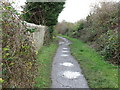
Public Bridleway near Burradon
This public bridleway links the urban sprawl of Killingworth New Town with a plethora of footpaths and tracks. This bridleway follows the course of an old mineral railway which linked Burradon Colliery to the immediate north with Killingworth Colliery to the south. For a selection of detailed free to download walking routes in the area visit www.northtynesidewalks.co.uk
Image: © Geoff Holland
Taken: 17 Nov 2020
0.06 miles
3
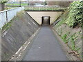
Underpass near Killingworth
This underpass links the urban sprawl of Killingworth New Town with the network of old waggonways and footpaths lying to the north. For a selection of detailed free to download walking routes in the area visit www.northtynesidewalks.co.uk
Image: © Geoff Holland
Taken: 17 Nov 2020
0.10 miles
5
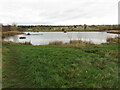
Pond, Burradon
This pond lies on an area of land once occupied by Burradon Colliery. The colliery was sunk in the 1820s along with a waggonway running from the colliery to Killingworth Colliery to the south. From there the coal from Burradon Colliery continued its journey along waggonways to the River Tyne. On the 2nd March 1860, an explosion at Burradon Colliery killed 76 men and boys and the disaster took on national significance at a time when mining safety was poor and the families of disaster victims had to rely on charity. The colliery eventually closed on the 22nd November 1975. For a selection of detailed free to download walking routes in the area visit www.northtynesidewalks.co.uk
Image: © Geoff Holland
Taken: 17 Nov 2020
0.19 miles
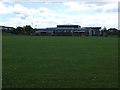
6
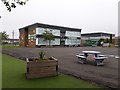
Bailey Green Primary School, West Bailey, Killingworth
A large primary school located on the north side of West Bailey in Killingworth.
Image: © Graham Robson
Taken: 13 Jun 2020
0.21 miles
7
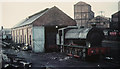
Burradon NCB shed, shortly before closure.
Image: © Roger Cornfoot
Taken: Unknown
0.22 miles
8
Fryer's Millennium Green, Burradon
When the second edition of the Ordnance Survey Six-Inch map of the area was published in 1898 this area was the site of Fryer's Terrace. Subsequently, in 1954, the properties in Fryer's Terrace were demolished and the area became derelict for many years. The project to create the Millennium Green was organised by the Burradon & Camperdown Forum and was officially opened in 2001. The land is now owned and maintained by North Tyneside Council. For a selection of detailed free to download walking routes in the area visit www.northtynesidewalks.co.uk
Image: © Geoff Holland
Taken: 17 Nov 2020
0.22 miles
9
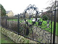
Decorative Railings, Fryer's Millennium Green, Burradon
When the second edition of the Ordnance Survey Six-Inch map of the area was published in 1898 this area was the site of Fryer's Terrace. Subsequently, in 1954, the properties in Fryer's Terrace were demolished and the area became derelict for many years. The project to create the Millennium Green was organised by the Burradon & Camperdown Forum and was officially opened in 2001. These railings lie on the western boundary of the Millennium Green. The land is now owned and maintained by North Tyneside Council. For a selection of detailed free to download walking routes in the area visit.
Image: © Geoff Holland
Taken: 17 Nov 2020
0.22 miles
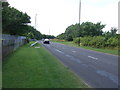
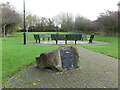
10
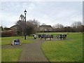
Fryers Millennium Green, Burradon
A crossing of Burradon Road, B1505 near the centre of Burradon. To the left is Fryers Millennium Green, a urban renewal scheme which was approved by the Countryside Commission as a Millennium Green and was opened in 2001. The benches are her covered with floral tributes to a local resident who died at the end of 2011.
Image: © Oliver Dixon
Taken: 23 Feb 2012
0.25 miles