IMAGES TAKEN NEAR TO
Malvern Gardens, GATESHEAD, NE11 9LJ
Introduction
This page details the photographs taken nearby to Malvern Gardens, NE11 9LJ by members of the Geograph project.
The Geograph project started in 2005 with the aim of publishing, organising and preserving representative images for every square kilometre of Great Britain, Ireland and the Isle of Man.

There are currently over 7.5m images from over14,400 individuals and you can help contribute to the project by visiting https://www.geograph.org.uk
Image Map (Loading...)


Getting Data...Please wait
Leaflet Map data © OpenStreetMap
Images are licensed for reuse under creativecommons.org/licenses/by-sa/2.0
Notes
- Clicking on the map will re-center to the selected point.
- The higher the marker number, the further away the image location is from the centre of the postcode.
Image Listing (16 Images Found)
Images are licensed for reuse under creativecommons.org/licenses/by-sa/2.0
Image
Details
Distance
1
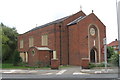
The Immaculate Heart of Mary R.C. Church
Image: © Bill Henderson
Taken: 23 Sep 2008
0.16 miles
2
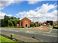
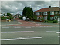
Top of Malvern Gardens
The junction with Whickham Highway. The church is the Immaculate Heart of Mary R C church, Lobley Hill.
Image: © Robert Graham
Taken: 8 Aug 2012
0.17 miles
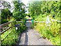
3
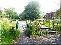
Crossing point on the Tanfield Railway Path
Here the Tanfield Railway Path crosses the Whickham Highway B6317 at Lobley Hill with a central refuge in the road. In the foreground are an A-type access control for cyclists and a horse stile.
Image: © Oliver Dixon
Taken: 24 Jul 2019
0.18 miles
4
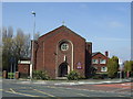
The Immaculate Heart of Mary Roman Catholic Church
Image: © JThomas
Taken: 2 May 2013
0.18 miles
6
Access control on the Tanfield Railway Path
An A-type access control at Lobley Hill on the Tanfield Railway Path leading to the Watergate Forest Park. The metal artwork is by Crook-based artist Graeme Hopper.
Image: © Oliver Dixon
Taken: 24 Jul 2019
0.21 miles
7
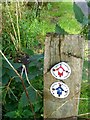
Waymarkers in Watergate Forest Park
The waymarkers refer to two of the three waymarked trails in the Watergate Forest Park - the 4.7 km Watergate and Washingwell Wander, for walkers and the 5.4 km Watergate Rider's Route which is also accessible for horse riders and cyclists.
Image: © Oliver Dixon
Taken: 24 Jul 2019
0.21 miles
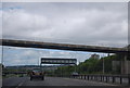
8
Approaching Lobley Hill
A1 southbound Newcastle
Image: © Les Harvey
Taken: 20 Apr 2008
0.21 miles
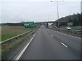
10

Dunston : A1
Looking north along the A1.
Image: © Lewis Clarke
Taken: 21 Sep 2020
0.23 miles