IMAGES TAKEN NEAR TO
Annette Road, LONDON, N7 6EF
Introduction
This page details the photographs taken nearby to Annette Road, N7 6EF by members of the Geograph project.
The Geograph project started in 2005 with the aim of publishing, organising and preserving representative images for every square kilometre of Great Britain, Ireland and the Isle of Man.

There are currently over 7.5m images from over14,400 individuals and you can help contribute to the project by visiting https://www.geograph.org.uk
Image Map
Images are licensed for reuse under creativecommons.org/licenses/by-sa/2.0
Notes
- Clicking on the map will re-center to the selected point.
- The higher the marker number, the further away the image location is from the centre of the postcode.
Image Listing (279 Images Found)
Images are licensed for reuse under creativecommons.org/licenses/by-sa/2.0
Image
Details
Distance
1
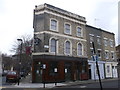
Former pub, Lower Holloway
This public house on the junction of Lowman Road and Annette Road (on the right) was called 'El Comandante' a few years ago. Formerly it was the Lord Palmerston, clues to its reinvention are subtle: a small poster in the window and the glass in the old Watney's lantern replaced with something a little more, well, revolutionary. Essentially, this was a South American bar in an old pub.
Image: © David Anstiss
Taken: 10 Mar 2013
0.01 miles
2
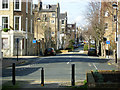
Annette Road, Lower Holloway
Seen from the junction with Jackson Road. The street has been barriered at various points, no doubt to prevent its use as a rat-run.
Image: © Stephen McKay
Taken: 8 Mar 2007
0.03 miles
3
Looking up Jackson Road and Lowman Road, from Hornsey Road
Image: © Christopher Hilton
Taken: 19 Jan 2017
0.04 miles
4
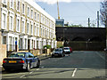
Dunford Road, Lower Holloway
This road ends abruptly at the arches carrying the East Coast Main Line, suggesting that the building of the railway truncated it.
Image: © Stephen McKay
Taken: 8 Mar 2007
0.05 miles
5
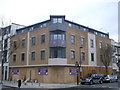
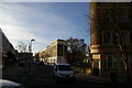
New housing, Holloway
This new block of apartments has been built on the junction of Hornsey Road and Caedmon Road (on the right).
Image: © David Anstiss
Taken: 10 Mar 2013
0.07 miles
6
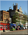
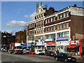
Holloway Road, London N7
One of the busiest roads in London, Holloway Road carries the A1 from Archway to Highbury Corner. This view takes in the Herbert Chapman public house, named after the successful manager of the nearby Arsenal Football Club in the 1930s, a "ghost sign" for a long-departed piano retailer, and more contemporary phenomenon, a nest of mobile phone masts.
Image: © Jim Osley
Taken: 8 Apr 2011
0.08 miles
8
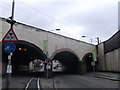
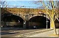
Railway bridge over Hornsey Road
Hornsey Road leads from Finsbury Park to Lower Holloway.
It passes under the railway between Holloway Road to Finsbury Park stations.
It has pedestrian tunnels either side with cycle lanes.
Image: © David Anstiss
Taken: 10 Mar 2013
0.08 miles
9
Holloway Road
Holloway Road forms part of the A1 Great North Road, which ultimately leads to Edinburgh. The name Holloway means the 'way in the hollow', this being a low-lying area between Highgate and Islington.
Image: © Stephen McKay
Taken: 8 Mar 2007
0.08 miles
10
Railway bridge over Hornsey Road
The two side arches are both used for cycle lanes.
Image: © Christopher Hilton
Taken: 19 Jan 2017
0.08 miles