IMAGES TAKEN NEAR TO
Lancaster Road, LONDON, N4 4PS
Introduction
This page details the photographs taken nearby to Lancaster Road, N4 4PS by members of the Geograph project.
The Geograph project started in 2005 with the aim of publishing, organising and preserving representative images for every square kilometre of Great Britain, Ireland and the Isle of Man.

There are currently over 7.5m images from over14,400 individuals and you can help contribute to the project by visiting https://www.geograph.org.uk
Image Map
Images are licensed for reuse under creativecommons.org/licenses/by-sa/2.0
Notes
- Clicking on the map will re-center to the selected point.
- The higher the marker number, the further away the image location is from the centre of the postcode.
Image Listing (79 Images Found)
Images are licensed for reuse under creativecommons.org/licenses/by-sa/2.0
Image
Details
Distance
1
View From Stroud Green
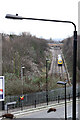
Looking down on the Tottenham and Hampstead Railway from the Great Northern Railway's Finsbury Park to Alexandra Palace branch. The latter is now a footpath known as The Parkland Walk and was a victim of Dr. Beeching's cuts. The Tottenham and Hampstead Railway's line survived because of its importance as a freight link across London. This view is taken from the site of the platforms of Stroud Green station. The diesel multiple unit is a class 172. The type recently replaced class 150's on the Barking - Gospel Oak service.
Image: © Martin Addison
Taken: 28 Jan 2011
0.02 miles
2
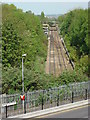
Gospel Oak to Barking Line from Parkland Walk
Seen from Parkland Walk which was itself formerly a railway line. Lancaster Road is in the foreground
Image: © Oxyman
Taken: 22 Apr 2009
0.03 miles
3
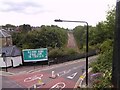
Road and rail, viewed from Parkland Walk
The road in the bottom left hand corner of the photograph and passing beneath Parkland Walk is Stapleton Hall Road. The road passing over the railway is Lancaster Road, whilst the railway is the London Overground from Barking between Crouch Hill and Harringay Green Lanes stations. Looking north-northeast from the Parkland Walk viaduct.
Image: © Robert Lamb
Taken: 27 Jul 2010
0.07 miles
4
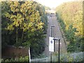
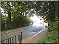
The railway line by Lancaster Road, Crouch End
This is taken from the old railway bridge opposite so gives the view from above rather than ground level.
Image: © David Howard
Taken: 9 Sep 2014
0.08 miles
6
View from Parkland Walk, looking northeast
Taken from the same place as Image, this shows the Gospel Oak to Barking line far below, showing that it would have been possible to build an interchange here with the ex-GN line, where I am standing. Interestingly, this would have become a second place where the UNDERground passes OVER the OVERground! (the other example of this being at Whitechapel).
Image: © Dr Neil Clifton
Taken: 7 Jan 2012
0.09 miles
9

The railway line by Lancaster Road, Crouch End
Compare with the view from above here http://www.geograph.org.uk/photo/4158378
Image: © David Howard
Taken: 9 Sep 2014
0.09 miles
10
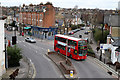
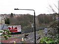
View From Stroud Green Station
In truth the station no longer exists and the line that served it has been converted into The Parkland Walk, but this is the view of the surrounding streets that passengers would have enjoyed from the Finsbury Park bound platform. On the left is Ferme Park Road. in the foreground is Stapleton Hall Road which continues on behind the bus, curving round to the right. The other road behind the bus, curving to the left, is Granville Road. The building which is just visible on the extreme left of the photo is the Stationmaster's house for Stroud Green Station and was already in use as a shop by 1930!
The W3 bus is on its way to Finsbury Park from Northumberland Park. Operated by Arriva, it is a Wright Gemini bodied Volvo B7TL.
Image: © Martin Addison
Taken: 28 Jan 2011
0.09 miles