IMAGES TAKEN NEAR TO
Holmwood Gardens, LONDON, N3 3NS
Introduction
This page details the photographs taken nearby to Holmwood Gardens, N3 3NS by members of the Geograph project.
The Geograph project started in 2005 with the aim of publishing, organising and preserving representative images for every square kilometre of Great Britain, Ireland and the Isle of Man.

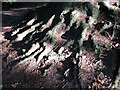
There are currently over 7.5m images from over14,400 individuals and you can help contribute to the project by visiting https://www.geograph.org.uk
Image Map
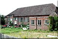
Images are licensed for reuse under creativecommons.org/licenses/by-sa/2.0
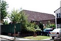
Notes
- Clicking on the map will re-center to the selected point.
- The higher the marker number, the further away the image location is from the centre of the postcode.
Image Listing (73 Images Found)
Images are licensed for reuse under creativecommons.org/licenses/by-sa/2.0
Image
Details
Distance
2
St Luke, Mountfield, London N3
Disused church
Image: © John Salmon
Taken: 31 Jul 2004
0.07 miles
3
St Luke, Mountfield, London N3
Disused church
Image: © John Salmon
Taken: 31 Jul 2004
0.07 miles
4

Ordnance Survey Cut Mark
This OS cut mark can be found on the north side of the road. It has been cancelled with a cross running above the cut.
Image: © Adrian Dust
Taken: 2 Aug 2016
0.09 miles
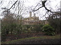
5
Roots
In Avenue House park, the roots of a Horse Chestnut are exposed by erosion of the soil. There are a number of hillocks within the park and all similarly display exposed tree roots.
Image: © Martin Addison
Taken: 12 Jul 2006
0.10 miles
6
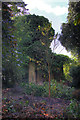
The Water Tower, Avenue House
Grade II listed building within the gardens. It is in poor condition and appears to be used as a store for compost.
Image: © Martin Addison
Taken: 16 Oct 2008
0.10 miles
7
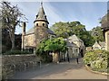
Avenue House stables, Finchley
Now containing the offices for Stephens House, where the ink manufacturer is from.
Image: © David Howard
Taken: 23 Jun 2020
0.10 miles
8
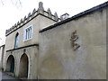
The Bothy, Finchley
Early example of a reinforced concrete structure and Grade II Listed Building which lies in the grounds of the Avenue Estate.The Bothy was designed to explore and research the breeding of livestock and animal husbandry.
Image: © Richard Rogerson
Taken: 17 Nov 2015
0.10 miles
9
Finchley: Avenue House: The Bothy, East End Road, N3
The Bothy was built as a walled garden in the form of a Moorish castle when Henry Charles (Inky) Stephens had the gardens of Avenue House landscaped around 1882. It is a Grade II Listed Building and the English Heritage Listed Buildings website describes it thus:-
"Garden walls including summerhouses, living accommodation, aquatic tank and cart storage. Built of massed concrete. Comprises a rectangle of garden walls about 12 feet in height with triangular buttresses at regular intervals. West side has projecting central porch with round-headed arch with Gibbs surround and there are four octagonal towers at the four corners with Moorish style triangular crenellations. The centre of the east front incorporates a two storeyed house with parapet in the Moorish style with triangular crenellations, arched entrance and casement windows, which provided accommodation for the gardeners. This is flanked by one storey buildings with arched openings probably used for the storage of carts and other gardening equipment."
The Bothy is currently in a run-down state with at least one notice stating "Dangerous structure - keep out".
Image: © Nigel Cox
Taken: 20 Feb 2011
0.11 miles
10
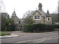
Finchley: Avenue House Lodge & Stables, East End Road, N3
These are the lodge and stables to Image There is also a coach house in this cluster of buildings, which were constructed around 1880, shortly after Henry Charles (Inky) Stephens bought the main house. The stables and coach house are Grade II Listed Buildings.
Image: © Nigel Cox
Taken: 20 Feb 2011
0.12 miles