IMAGES TAKEN NEAR TO
Cromwell Road, LONDON, N3 2ET
Introduction
This page details the photographs taken nearby to Cromwell Road, N3 2ET by members of the Geograph project.
The Geograph project started in 2005 with the aim of publishing, organising and preserving representative images for every square kilometre of Great Britain, Ireland and the Isle of Man.

There are currently over 7.5m images from over14,400 individuals and you can help contribute to the project by visiting https://www.geograph.org.uk
Image Map
Images are licensed for reuse under creativecommons.org/licenses/by-sa/2.0
Notes
- Clicking on the map will re-center to the selected point.
- The higher the marker number, the further away the image location is from the centre of the postcode.
Image Listing (158 Images Found)
Images are licensed for reuse under creativecommons.org/licenses/by-sa/2.0
Image
Details
Distance
1
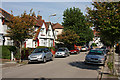
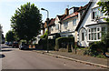
Cromwell Road
Semi-detached housing on Cromwell Road, looking towards Avondale Road.
Image: © Martin Addison
Taken: 20 Sep 2008
0.03 miles
2
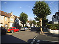
Avondale Road at the junction of Montpelier Road
Image: © David Howard
Taken: 21 Aug 2015
0.03 miles
3
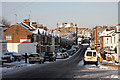
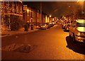
Long Lane
Looking across the dip by Cromwell and Montpelier Road's from the junction with Abingdon Road. The dip forms the lowest point along the lane and is sometimes liable to flooding. Beyond the Lane climbs up to the junction with Squires Lane before a kink to the left and continuing its climb to Church End and Ballards Lane.
Not too sure what the driver of the Mercedes was doing but it doesn't seem to have involved hitting anything. Long Lane was gritted but the snow has stuck to the road regardless as the temperatures fell below Zero and stayed there.
Image: © Martin Addison
Taken: 7 Jan 2010
0.03 miles
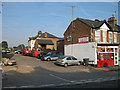
4
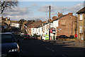
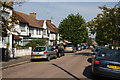
Long Lane
Looking along the lane towards the junction with Squires Lane at the traffic lights in the distance. The nearest side road with newsagents on the corner is Abingdon Road. A large advertising hoarding has recently been removed from the side of the shop and the site of a much smaller previous one revealed. At the bottom of the hill is Cromwell Road (behind the red van) and halfway up the hill to Squires Lane is Montpelier Road
Image: © Martin Addison
Taken: 29 Nov 2007
0.03 miles
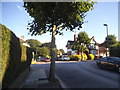
5
Montpelier Road
Terraced and semi-detached housing in this view looking towards Long Lane.
Image: © Martin Addison
Taken: 20 Sep 2008
0.04 miles
6
Abingdon Road
Mixed terraced and semi-detached housing.
Image: © Martin Addison
Taken: 20 Sep 2008
0.05 miles
7
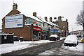
Shops and Snow
The shopkeeper of Unique Food and Wine has just completed clearing the pavement outside his shop. No doubt it will soon be covered again as the snow is still falling.
Image: © Martin Addison
Taken: 2 Feb 2009
0.05 miles
9
Nursery Avenue N3
Nursery Avenue takes its name from the former existence of a Nursery behind this part of Long Lane. The nursery was given over to allotments (Pointalls) in 1921. Entrance gates to the allotments are just visible on the Left between the parked cars, though the main entrance is off Squires Lane. Central Hire Services, on the corner, lease a wide variety of building / landscaping tools. It seems that someone has left an old bathtub as a deposit!
Image: © Martin Addison
Taken: 1 Jul 2006
0.06 miles
10
Avondale Road at the junction of Abingdon Road
Image: © David Howard
Taken: 21 Aug 2015
0.06 miles