IMAGES TAKEN NEAR TO
Avondale Road, LONDON, N3 2EP
Introduction
This page details the photographs taken nearby to Avondale Road, N3 2EP by members of the Geograph project.
The Geograph project started in 2005 with the aim of publishing, organising and preserving representative images for every square kilometre of Great Britain, Ireland and the Isle of Man.

There are currently over 7.5m images from over14,400 individuals and you can help contribute to the project by visiting https://www.geograph.org.uk
Image Map
Images are licensed for reuse under creativecommons.org/licenses/by-sa/2.0
Notes
- Clicking on the map will re-center to the selected point.
- The higher the marker number, the further away the image location is from the centre of the postcode.
Image Listing (152 Images Found)
Images are licensed for reuse under creativecommons.org/licenses/by-sa/2.0
Image
Details
Distance
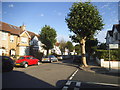
1
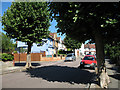
Avondale Road
Looking up the hill towards Squires Lane. The road on the left is Montpelier Road. The London Plane trees and are pollarded every year to keep them a sensible size - left to grow naturally they become very large trees.
Image: © Martin Addison
Taken: 18 Jul 2006
0.02 miles
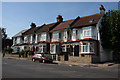
3
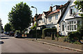
Montpelier Road
Terraced and semi-detached housing in this view looking towards Long Lane.
Image: © Martin Addison
Taken: 20 Sep 2008
0.03 miles
4
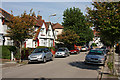
Cromwell Road
Semi-detached housing on Cromwell Road, looking towards Avondale Road.
Image: © Martin Addison
Taken: 20 Sep 2008
0.05 miles
5
Squires Lane
A short row of terraced houses beside the junction with Etchingham Park Road, on the right. The stone-cladding on the corner house doesn't quite work for me.
Image: © Martin Addison
Taken: 20 Sep 2008
0.05 miles
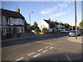
7
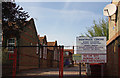
Manorside Centre
The sign tells you what services are housed here on part of the Manorside Primary School site.
Image: © Martin Addison
Taken: 20 Sep 2008
0.06 miles
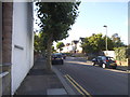
8
Avondale Road at the junction of Montpelier Road
Image: © David Howard
Taken: 21 Aug 2015
0.06 miles
9
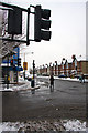
Junction of Squires Lane and Long Lane
Snow turned to slush at this busy intersection. Pedestrians skirt around the water by the crossing and icicles hang from the traffic lights. Don't let the water confuse you...it's still -1 degrees Celsius!
Image: © Martin Addison
Taken: 2 Feb 2009
0.06 miles
10
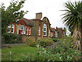
Manorside Primary School
Built in 1906 by the council as Squires Lane School, it was renamed Manor School in 1932 as part of the changes to education brought about by the Hadow Report. It was renamed again in 1936, becoming Manorside. In 1956 it became a girls only school, (the Alder, in Long Lane becoming Boys only at the same time). It is now a primary school. Information from British History Online and Wikipedia.
Image: © Martin Addison
Taken: 31 Aug 2006
0.06 miles