IMAGES TAKEN NEAR TO
The Grove, LONDON, N3 1QJ
Introduction
This page details the photographs taken nearby to The Grove, N3 1QJ by members of the Geograph project.
The Geograph project started in 2005 with the aim of publishing, organising and preserving representative images for every square kilometre of Great Britain, Ireland and the Isle of Man.

There are currently over 7.5m images from over14,400 individuals and you can help contribute to the project by visiting https://www.geograph.org.uk
Image Map
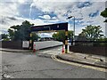
Images are licensed for reuse under creativecommons.org/licenses/by-sa/2.0
Notes
- Clicking on the map will re-center to the selected point.
- The higher the marker number, the further away the image location is from the centre of the postcode.
Image Listing (236 Images Found)
Images are licensed for reuse under creativecommons.org/licenses/by-sa/2.0
Image
Details
Distance
2
Tesco car park in Finchley Central
It's like a maze starting on the surface and heading downstairs. It's quite small compared to the size of the shop but somehow we always managed to get a space while my grandparents were alive.
Image: © David Howard
Taken: 30 May 2022
0.03 miles
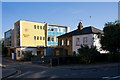
4
Tesco's Car Park
On the opposite side of Popes drive to the store. Alexander House is visible on the left.
Image: © Martin Addison
Taken: 12 Jul 2008
0.05 miles
5
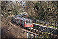
Approaching Finchley Central
A southbound Northern Line train rounds the tight bend on the High Barnet branch at Finchley Central. The pronounced cant applied to the track is evident from the photo as well as the check rail alongside the inner running rail. The train is routing to Morden via Bank.
Image: © Martin Addison
Taken: 12 Feb 2008
0.05 miles
6
Shakespeare Road
A short cul-de-sac off Popes Drive. Alexander House is home to a number of small companies.
Image: © Martin Addison
Taken: 12 Jul 2008
0.06 miles
7
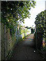
Lovers Walk
View along Lovers Walk as it crosses over the High Barnet branch of the Northern Line. The high sides and cage are relatively recent additions to the bridge. The original lattice girder construction is just visible in the shaded area (lower left centre).
Image: © Martin Addison
Taken: 16 Jun 2006
0.07 miles
8
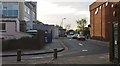
Popes Drive, Finchley
The access road for the Tesco car park
Image: © David Howard
Taken: 3 May 2016
0.08 miles
9
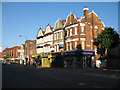
Ballards Lane
Shops on Ballards Lane. The nearest shops date from around 1900. Unusually, there are windows in the upper storey of the end of terrace building, (The same is true of the adjacent block - out of shot on the right). The more modern building immediately adjacent was the Post Office, but closed in 2005. It is now a shop selling artworks. On the left of the photo is Tesco's Finchley Central branch - a modern, functional and bland building.
Image: © Martin Addison
Taken: 12 Jul 2006
0.08 miles
10
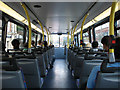
On the 82
The top deck of an 82 bus with mid-morning passengers as it passes along Ballards Lane in Finchley Central. The building visible through the left windows is the Nat West Bank, whilst on the right is Tesco's. Ahead is the bridge over the Northern Line, where we enter Regents Park Road. In the distance is the old Barclays Bank building and King Edward Hall. The bus routes from North Finchley to Victoria.
Image: © Martin Addison
Taken: 14 Sep 2006
0.08 miles