IMAGES TAKEN NEAR TO
King Street, LONDON, N2 8PB
Introduction
This page details the photographs taken nearby to King Street, N2 8PB by members of the Geograph project.
The Geograph project started in 2005 with the aim of publishing, organising and preserving representative images for every square kilometre of Great Britain, Ireland and the Isle of Man.

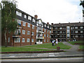
There are currently over 7.5m images from over14,400 individuals and you can help contribute to the project by visiting https://www.geograph.org.uk
Image Map
Images are licensed for reuse under creativecommons.org/licenses/by-sa/2.0
Notes
- Clicking on the map will re-center to the selected point.
- The higher the marker number, the further away the image location is from the centre of the postcode.
Image Listing (309 Images Found)
Images are licensed for reuse under creativecommons.org/licenses/by-sa/2.0
Image
Details
Distance
1
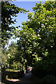
Footpath beside Ferrour Court
This footpath is an extension of The Walks and used to pass between the Alder School and the Elim Church on King Street, both now replaced by housing. At the end of the path is Elmfield Road by the junction with Red Lion Hill. The large flowering tree on the right is a member of the Catalpa family, probably an Indian Bean (Catalpa bignonioides).
Image: © Martin Addison
Taken: 22 Jul 2008
0.01 miles
2
Ferrour Court
Built on the site of the Elim church in King Street, this block of flats was constructed as part of the redevelopment of the Alder school after it was closed. The alley to the left passed between the church and the school wall and was a popular venue for after school fights. This photo is taken from the approximate location of the schools rear gate - now an alley into the rest of the estate. The branches in the foreground belong to a London Plane tree (Platinus X Hispanica). Its globular seed heads are visible - the seeds are not normally fertile and almost all London Plane trees are produced from cuttings.
Image: © Martin Addison
Taken: 11 Dec 2007
0.03 miles
3
Claybrook Close
This housing development was built on the site of the Alder Secondary School. I'm standing roughly in one corner of the playground. The group of houses in the centre of the photo occupy the area where the front of the school itself was. The school building extended back to roughly where the nearest block of houses starts. The houses on the left of the photo are on Long Lane.
Image: © Martin Addison
Taken: 11 Jan 2010
0.03 miles
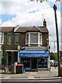
4
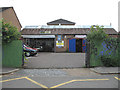
H&B Motor Engineers
Sited on King Street; MOT and car repair specialists. The building was originally the workshop of a light engineering company which sadly closed some years ago.
Image: © Martin Addison
Taken: 15 Jun 2006
0.03 miles
5
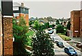
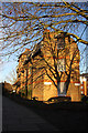
Grange Estate & Central Avenue, August 1997
View of the Grange Estate & Central Avenue from 12, Vane House looking toward King Street, Elmfield Road & Red Lion Hill junction. Blocks Elmfield House (left) and Garden House (right) can be seen, as well as The Red Lion pub which is sitting just behind, and to the right of, Garden House. Built circa 1907, this Edwardian building was situated on the site of an Inn which dated back to 1714, originally called The Rabbit; it was renamed The Red Lion circa 1789. Unfortunately this pub no longer stands. Also visible in the middle of the photo, peeking out of the shrubbery and sitting on the opposite side of the road to The Red Lion, is the old caretaker's house which was originally part of the former Alder School, a Secondary school which sat behind the row of houses going up Elmfield Road. This was demolished in 1979 when the school was merged with Christ's College Finchley (my alma mater) when it went Comprehensive in 1978. Also demolished at the same time was Elim Church; this was situated out of view behind Elmfield House in King Street. Both sites are now occupied by new housing which was built in 1979-1981.
Image: © Alexander Barison
Taken: 4 Aug 1997
0.03 miles
7
Alder Court
Modern flats built on the site of the Alder Secondary School. The school was closed in 1978. One last remnant of the school remains - the pale blue gatepost in the wall on the left of the picture. History of the Alder School at http://en.wikipedia.org/wiki/Christ%27s_College%2C_East_Finchley .
Image: © Martin Addison
Taken: 23 Jun 2006
0.04 miles
8
Garden House, Grange Estate, East Finchley
Garden House (built circa 1949), Central Avenue on the Grange Estate as seen from my balcony at 12, Vane House on 4 August 1997. In the distance the Red Lion pub can be seen, built circa 1907 on the site of an Inn which originally dated back to 1714 and opened as 'The Rabbit'. It was situated on the corner of Red Lion Hill but unfortunately this lovely example of Edwardian architecture has since been demolished.
Image: © Alexander Barison
Taken: 4 Aug 1997
0.05 miles
9
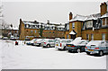
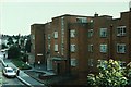
Foskett House and Sycamore House
Further examples of housing on the Grange Estate. In recent years some of the housing blocks have been cleaned and modernised. The old tile roof has been removed from Foskett House and a new floor of residences added. Sycamore House, in the background, retains its original roof profile and has yet to be cleaned.
Image: © Martin Addison
Taken: 8 Jun 2006
0.05 miles
10
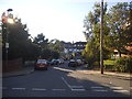
Longlane Newsagent
Local papershop and mini market. The sign maker seems to have decided that if Newsagent is one word then Long Lane must be too! Corner of Elmfield Road.
Image: © Martin Addison
Taken: 23 Jun 2006
0.05 miles