IMAGES TAKEN NEAR TO
Richmond Road, LONDON, N2 8JT
Introduction
This page details the photographs taken nearby to Richmond Road, N2 8JT by members of the Geograph project.
The Geograph project started in 2005 with the aim of publishing, organising and preserving representative images for every square kilometre of Great Britain, Ireland and the Isle of Man.

There are currently over 7.5m images from over14,400 individuals and you can help contribute to the project by visiting https://www.geograph.org.uk
Image Map
Images are licensed for reuse under creativecommons.org/licenses/by-sa/2.0
Notes
- Clicking on the map will re-center to the selected point.
- The higher the marker number, the further away the image location is from the centre of the postcode.
Image Listing (187 Images Found)
Images are licensed for reuse under creativecommons.org/licenses/by-sa/2.0
Image
Details
Distance
1
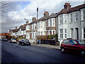
Long Lane Housing
Two examples of terrace housing styles in the N2 part of Long Lane.
Image: © Martin Addison
Taken: 16 Feb 2006
0.02 miles
2

Chamberlain Road
Terraced housing on Chamberlain Road, a cul-de-sac off Long Lane. The gates at the end provide maintenance access to the Northern Line.
Image: © Martin Addison
Taken: 29 Nov 2007
0.02 miles

4

Green Lane
The east end of this disused lane at the junction with Long Lane. A small van hire company has set up its office here. The lane continued between the trees in the centre of the picture to a bridge over the Northern Line and then on to a junction with East End Road, where Briarfield Avenue is now. Please see other views of Green Lane on this site.
Image: © Martin Addison
Taken: 12 Jul 2008
0.05 miles
5
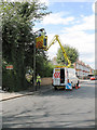
Streetlamp Maintenance
With the days getting shorter as autumn begins, Barnet's highway maintenance team are out cleaning the streetlamps in Long Lane.
Image: © Martin Addison
Taken: 1 Sep 2006
0.05 miles
6
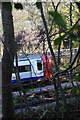
Green Lane
Looking across the Northern Line at the site of the bridge that carried the lane across the railway. On the opposite side, the lane continues down to join Long Lane between Manor Cottage Approach and Chamberlain Road. The bridge was built in the 1860's and demolished in the 1960's after the lane had fallen into disuse. The abutments of the bridge now carry number W987 for maintenance purposes.
Image: © Martin Addison
Taken: 16 Nov 2007
0.05 miles
7
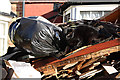
Foraging for Food
Mary complained to George that the foxes had been at the bin bags again.
Image: © Martin Addison
Taken: 12 Jan 2008
0.06 miles
8
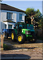
Urban Forestry
A nice collection of off road vehicles parked on the drive of a house on Long Lane while a Lawson's Cypress (Chamaecyparis lawsonia) is removed from a garden on Brighton Road. There were 2 of these trees and both were removed in little more than an hour. The tractor is a John Deere 6920S. The vehicle hiding behind the tractor is a Unimog.
Image: © Martin Addison
Taken: 8 Oct 2008
0.06 miles
9

Long Lane N2 - Accident
Aftermath of an accident in Long Lane. A speeding Vauxhall Omega struck this Saxo, spinning it round and dumping it on the pavement. Part of the wall was demolished in the process. Fortunately no pedestrians were passing at the time. The Omega was abandoned further down the Lane opposite Abingdon Road. It was the second accident on this corner inside a month. The gentle nature of the corner can be seen at http://www.geograph.org.uk/photo/193285
Image: © Martin Addison
Taken: 6 Mar 2006
0.06 miles
10
Green Lane
Remains of an old lane that ran between Long Lane and East End Road. The lane predates 1800 and probably fell into disuse with the advent of a metalled road adjacent - now the North Circular Road. The fence at the end marks the Northern Line boundary and prevents access to the railway where the lane used to cross on a bridge. The wall on the right is the back of the playing fields belonging to Bishop Douglas school.
Image: © Martin Addison
Taken: 12 Nov 2007
0.06 miles