IMAGES TAKEN NEAR TO
Blackdown Close, LONDON, N2 8JF
Introduction
This page details the photographs taken nearby to Blackdown Close, N2 8JF by members of the Geograph project.
The Geograph project started in 2005 with the aim of publishing, organising and preserving representative images for every square kilometre of Great Britain, Ireland and the Isle of Man.

There are currently over 7.5m images from over14,400 individuals and you can help contribute to the project by visiting https://www.geograph.org.uk
Image Map
Images are licensed for reuse under creativecommons.org/licenses/by-sa/2.0
Notes
- Clicking on the map will re-center to the selected point.
- The higher the marker number, the further away the image location is from the centre of the postcode.
Image Listing (199 Images Found)
Images are licensed for reuse under creativecommons.org/licenses/by-sa/2.0
Image
Details
Distance
1
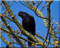
Corvus Curiosa
A Carrion Crow (Corvus corone) eyes me warily from a tree beside Simms Gardens - He's wondering what the thing I'm pointing at him is but obviously doesn't think it's a shot-gun otherwise he'd be off! The tree itself has quite a healthy growth of lichens, suggesting that the air quality isn't too bad.
Image: © Martin Addison
Taken: 19 Mar 2011
0.03 miles
2
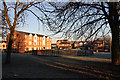
Cold and Frosty Morning
View of the housing estate built on the site of Simms factory. The block of flats on the left are on a part of Brendan Grove, whilst the houses behind the fenced play area are on Taunton Drive. Swings and slide have been removed from the play area. The landscaped grass in the foreground was the site of Oak Lodge - once a manor house and in its last years, a school for special needs children.
Image: © Martin Addison
Taken: 12 Dec 2007
0.04 miles
3
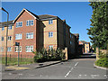
Simms Gardens
Viewed from Tarling Road, Simms Gardens recalls the name of the founder of Simms Motor Units, subsequently part of Lucas CAV. This is part of the housing estate built following the closure of the factory on this site. This area was the car park. Previously, it had been allotments. The road, which routes through to Long Lane, is divided in the middle to prevent through traffic and is called Lucas Gardens at the other end.
Image: © Martin Addison
Taken: 18 Jul 2006
0.04 miles
4
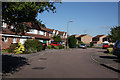
Brendon Grove
Some of the houses on this estate that back onto Long Lane.
Image: © Martin Addison
Taken: 22 Jul 2008
0.05 miles
5

Lucas Gardens
Part of a housing estate built on the site of the old Simms Factory. This road takes its name for Lucas who took over Simms. The area on which these apartments stand was the car park. Previously, it had been allotments. The road connects to Long Lane at the far end. It is divided in the middle to prevent through traffic and the section behind me is called Simms Gardens at the other end.
Image: © Martin Addison
Taken: 18 Jan 2013
0.06 miles
6
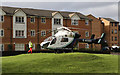
Emergency Attendance
The London Air Ambulance attends and emergency on Brendon Grove. This particular helicopter, a McDonnell-Douglas MD902 Explorer was in service with the Surrey Air Ambulance. The London Air Ambulance service has been fund raising for a second helicopter to join their regular MD902 G-EHMS. So whether this is a temporary loan or a permanent deployment remains to be seen.
Image: © Martin Addison
Taken: 1 Feb 2014
0.06 miles
7

Robin
Erithacus rubecula - Perched on the wheelbarrow handle between trips to the feeding station.
Image: © Martin Addison
Taken: 8 Jan 2010
0.06 miles
8
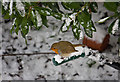
Robin
Erithacus rubecula - using the wheelbarrow as a perch under the leaves of the Strawberry Tree (Arbutus unedo).
Image: © Martin Addison
Taken: 7 Jan 2010
0.06 miles
9
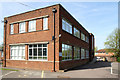
Oak Lane Clinic
The Oak Lane Clinic - built, I believe, in the 1940's. It was refurbished in 2010.
Image: © Martin Addison
Taken: 10 Apr 2011
0.06 miles
10
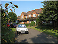
Wilmot Close
Alms Houses for the elderly. Additional houses have been added over the years.
Image: © Martin Addison
Taken: 16 Jun 2006
0.07 miles