IMAGES TAKEN NEAR TO
Taunton Drive, LONDON, N2 8JD
Introduction
This page details the photographs taken nearby to Taunton Drive, N2 8JD by members of the Geograph project.
The Geograph project started in 2005 with the aim of publishing, organising and preserving representative images for every square kilometre of Great Britain, Ireland and the Isle of Man.

There are currently over 7.5m images from over14,400 individuals and you can help contribute to the project by visiting https://www.geograph.org.uk
Image Map
Images are licensed for reuse under creativecommons.org/licenses/by-sa/2.0
Notes
- Clicking on the map will re-center to the selected point.
- The higher the marker number, the further away the image location is from the centre of the postcode.
Image Listing (219 Images Found)
Images are licensed for reuse under creativecommons.org/licenses/by-sa/2.0
Image
Details
Distance
1

Emergency Attendance
The London Air Ambulance attends and emergency on Brendon Grove. This particular helicopter, a McDonnell-Douglas MD902 Explorer was in service with the Surrey Air Ambulance. The London Air Ambulance service has been fund raising for a second helicopter to join their regular MD902 G-EHMS. So whether this is a temporary loan or a permanent deployment remains to be seen.
Image: © Martin Addison
Taken: 1 Feb 2014
0.01 miles
2
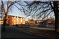
Cold and Frosty Morning
View of the housing estate built on the site of Simms factory. The block of flats on the left are on a part of Brendan Grove, whilst the houses behind the fenced play area are on Taunton Drive. Swings and slide have been removed from the play area. The landscaped grass in the foreground was the site of Oak Lodge - once a manor house and in its last years, a school for special needs children.
Image: © Martin Addison
Taken: 12 Dec 2007
0.02 miles
3
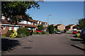
Brendon Grove
Some of the houses on this estate that back onto Long Lane.
Image: © Martin Addison
Taken: 22 Jul 2008
0.03 miles
4
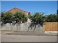
Factory Gates
A pavement crossing marks the site of the Lucas CAV factory's New Oak Road entrance. Simms' factory opened on this site in 1926 utilising a victorian mansion and its grounds. A successful business, supplying motor parts, it expanded to fill the whole of the six acre site. In 1968 the company was taken over by Lucas CAV. With the UK motor business losing market share, the factory was gradually run down and finally closed in 1991. At one time it was Finchley's largest employer. I used to meet my father here at the end of his shift. It is now a housing estate
Image: © Martin Addison
Taken: 18 Jul 2006
0.04 miles
5
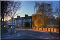
Oak Lane
Looking towards the junction with New Oak Road from the junction with Taunton Drive (foreground). Blackbirds sit at the top of the Silver Birch tree, squabbling about territories. It is a bright cold morning.
Image: © Martin Addison
Taken: 2 Dec 2008
0.05 miles
6
Oak Lane Clinic
The Oak Lane Clinic - built, I believe, in the 1940's. It was refurbished in 2010.
Image: © Martin Addison
Taken: 10 Apr 2011
0.05 miles
7
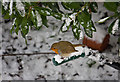
Robin
Erithacus rubecula - using the wheelbarrow as a perch under the leaves of the Strawberry Tree (Arbutus unedo).
Image: © Martin Addison
Taken: 7 Jan 2010
0.05 miles
8

Long Tailed Tits
A family of Long Tailed Tits (Aegithalos caudatus) stop off to feed and preen in a Rowan Tree. The group consisted of 9 birds.
Image: © Martin Addison
Taken: 29 Aug 2006
0.05 miles
9
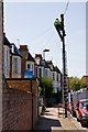
Linesman at Work
A BT Openreach field engineer works up a pole to provide telephony services outside the terraced houses on New Oak Road.
Image: © Martin Addison
Taken: 22 Apr 2010
0.05 miles
10
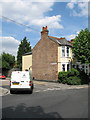
Junction Of New Oak Road with Long Lane
A van turns into New Oak Road from Long Lane. The corner terraced house retains its original slate roof complete with finials.
Image: © Martin Addison
Taken: 23 Jun 2006
0.06 miles