IMAGES TAKEN NEAR TO
King Street, LONDON, N2 8DY
Introduction
This page details the photographs taken nearby to King Street, N2 8DY by members of the Geograph project.
The Geograph project started in 2005 with the aim of publishing, organising and preserving representative images for every square kilometre of Great Britain, Ireland and the Isle of Man.

There are currently over 7.5m images from over14,400 individuals and you can help contribute to the project by visiting https://www.geograph.org.uk
Image Map
Images are licensed for reuse under creativecommons.org/licenses/by-sa/2.0
Notes
- Clicking on the map will re-center to the selected point.
- The higher the marker number, the further away the image location is from the centre of the postcode.
Image Listing (308 Images Found)
Images are licensed for reuse under creativecommons.org/licenses/by-sa/2.0
Image
Details
Distance
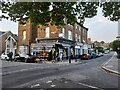
1
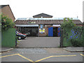
H&B Motor Engineers
Sited on King Street; MOT and car repair specialists. The building was originally the workshop of a light engineering company which sadly closed some years ago.
Image: © Martin Addison
Taken: 15 Jun 2006
0.00 miles
2
Ferrour Court
Built on the site of the Elim church in King Street, this block of flats was constructed as part of the redevelopment of the Alder school after it was closed. The alley to the left passed between the church and the school wall and was a popular venue for after school fights. This photo is taken from the approximate location of the schools rear gate - now an alley into the rest of the estate. The branches in the foreground belong to a London Plane tree (Platinus X Hispanica). Its globular seed heads are visible - the seeds are not normally fertile and almost all London Plane trees are produced from cuttings.
Image: © Martin Addison
Taken: 11 Dec 2007
0.01 miles
3
Claybrook Close
This housing development was built on the site of the Alder Secondary School. I'm standing roughly in one corner of the playground. The group of houses in the centre of the photo occupy the area where the front of the school itself was. The school building extended back to roughly where the nearest block of houses starts. The houses on the left of the photo are on Long Lane.
Image: © Martin Addison
Taken: 11 Jan 2010
0.02 miles
4
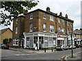
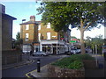
Neighbourhood Centre
An imposing block of shops on the corner of King Street and Church Lane. All now have different uses. On the corner is the Neighbourhood centre offering advice to local residents. In the centre is a lettings agency. Finally on the right of the block is the home of East Finchley Constituency Labour Party. Less weathered bricks on the corner of the building suggest a hoarding above the corner entrance, probably relating to the shop.
Image: © Martin Addison
Taken: 27 Jun 2006
0.03 miles
5
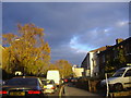
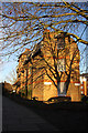
Storm clouds over Church Lane
No editing required, this was the natural light effect.
Image: © David Howard
Taken: 12 Nov 2008
0.03 miles
7
Filming on Church Lane
Lights and screens are set up in preparation for shooting a BBC commercial about the ease of buying your TV license online.
Image: © Martin Addison
Taken: 8 Apr 2011
0.03 miles
8
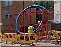
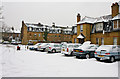
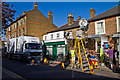
Water main replacement pipe, East Finchley
Image: © Jim Osley
Taken: 23 Jun 2015
0.04 miles
10
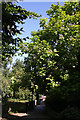
Footpath beside Ferrour Court
This footpath is an extension of The Walks and used to pass between the Alder School and the Elim Church on King Street, both now replaced by housing. At the end of the path is Elmfield Road by the junction with Red Lion Hill. The large flowering tree on the right is a member of the Catalpa family, probably an Indian Bean (Catalpa bignonioides).
Image: © Martin Addison
Taken: 22 Jul 2008
0.04 miles