IMAGES TAKEN NEAR TO
East End Road, LONDON, N2 8AU
Introduction
This page details the photographs taken nearby to East End Road, N2 8AU by members of the Geograph project.
The Geograph project started in 2005 with the aim of publishing, organising and preserving representative images for every square kilometre of Great Britain, Ireland and the Isle of Man.

There are currently over 7.5m images from over14,400 individuals and you can help contribute to the project by visiting https://www.geograph.org.uk
Image Map
Images are licensed for reuse under creativecommons.org/licenses/by-sa/2.0
Notes
- Clicking on the map will re-center to the selected point.
- The higher the marker number, the further away the image location is from the centre of the postcode.
Image Listing (355 Images Found)
Images are licensed for reuse under creativecommons.org/licenses/by-sa/2.0
Image
Details
Distance
1
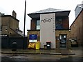
Dentists on East End Road, East Finchley
This was a public toilet till around the late 80s when it was abandoned, about 20 years ago it was given a second floor and became a dentists.
Image: © David Howard
Taken: 17 Apr 2020
0.00 miles
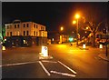
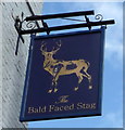
2
The Bald Faced Stag, East Finchley
At the junction of the High Road
Image: © David Howard
Taken: 15 Sep 2020
0.01 miles
3
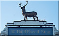
East Finchley - Bald faced stag
On the roofline of a public house in East Finchley
Image: © Jim Osley
Taken: 20 Jan 2019
0.01 miles
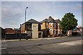
4
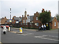
Bobath Centre
The Bobath Centre in East Finchley provides therapy for children suffering from Cerebral Palsy. The building was originally Holy Trinity Church of England School, built in 1847. The separate entrances for Boys and Girls are still in evidence. The white sign in front welcomes visitors to East Finchley Village Centre and displays the Archer symbol.
Image: © Martin Addison
Taken: 24 Apr 2006
0.01 miles
5
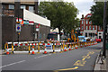
Roadworks on East End Road
A JCB excavator opens up a trench in preparation for laying new gas mains on East End Road.
Image: © Martin Addison
Taken: 1 Oct 2008
0.03 miles
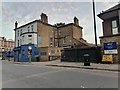
6
Dental Surgery
Housed in a modern style of building on East End Road, the darker yellow bricks on the lower walls hint at a previous use. This was once East Finchley's public convenience - conveniently placed behind the Bald Faced Stag public house (car park on the left).
Image: © Martin Addison
Taken: 20 Jun 2008
0.03 miles
7
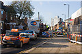
Congestion on East End Road
Drivers wait patiently while the driver of a grab lorry climbs back into his cab after collecting a load of spoil from the Gas Alliance roadworks.
Image: © Martin Addison
Taken: 3 Dec 2008
0.03 miles
8
Fortis Green at the junction of East Finchley High Road
Looking across the A504 towards its continuation on East End Road, the A road finishes at West Hendon Broadway on the A5. The Bald Faced Stag pub is on the corner opposite.
Image: © David Howard
Taken: 3 Mar 2014
0.03 miles
10
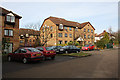
Deanery Close
Another 1980's housing development. The estate is built on an area of open land that sat between the railway line and a footpath leading down to East Finchley station. Approximately where I am standing, the footpath was carried over a siding in a cutting by a small bridge. It was constructed in the 1920's and I believe it was used to supply a builders merchant (Gray's?) at a time when the area was rapidly growing. The remains of the siding with one decomposing wagon were still there in the early 1970's. The main railway goods sidings were closer to the station and are now a car park.
Image: © Martin Addison
Taken: 5 Feb 2008
0.03 miles