IMAGES TAKEN NEAR TO
East End Road, LONDON, N2 0XH
Introduction
This page details the photographs taken nearby to East End Road, N2 0XH by members of the Geograph project.
The Geograph project started in 2005 with the aim of publishing, organising and preserving representative images for every square kilometre of Great Britain, Ireland and the Isle of Man.

There are currently over 7.5m images from over14,400 individuals and you can help contribute to the project by visiting https://www.geograph.org.uk
Image Map
Images are licensed for reuse under creativecommons.org/licenses/by-sa/2.0
Notes
- Clicking on the map will re-center to the selected point.
- The higher the marker number, the further away the image location is from the centre of the postcode.
Image Listing (140 Images Found)
Images are licensed for reuse under creativecommons.org/licenses/by-sa/2.0
Image
Details
Distance
1
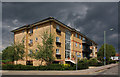
Apartments on Briar Close
Modern apartment block built on the site of the Manor Cottage Tavern.
Image: © Martin Addison
Taken: 22 Aug 2008
0.02 miles
2

Ordnance Survey Cut Mark
This OS cut mark can be found on a pillar in the cemetery wall to the south of East End Road. It marks a point 92.144m above mean sea level.
Image: © Adrian Dust
Taken: 2 Aug 2016
0.03 miles
3
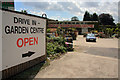
Finchley Manor Garden Centre
Once a very large garden centre and nursery. It was closed last year, but someone seems to have breathed some life back into it again.
Image: © Martin Addison
Taken: 22 Aug 2008
0.03 miles
4
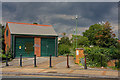
Marie Curie Cancer Care Garden of Hope
The main section of the garden is on the east side of East End Road. There is a path and seats under the lights. The garden is often home to those without hope. The building is an electricity sub-station.
Image: © Martin Addison
Taken: 22 Aug 2008
0.03 miles
5
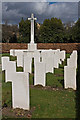
Fallen Heroes
The war graves section within Marylebone Cemetery. Not all war graves are within this plot, a few are dotted around the rest of the cemetery.
Image: © Martin Addison
Taken: 27 Feb 2008
0.03 miles
6

Marylebone Cemetery
Although the cemetery is now under the control of Westminster Council, the gates still display the Marylebone Borough Council coat of arms.
Image: © Martin Addison
Taken: 27 Feb 2008
0.04 miles
7
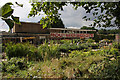
Finchley Manor Garden Centre
Customers walk amongst the pots and plants in the newly reopened garden centre.
Image: © Martin Addison
Taken: 22 Aug 2008
0.04 miles
8

Crazy School
Road markings warning motorists not to park by the entrance of Christ's College.
Image: © Martin Addison
Taken: 22 Aug 2008
0.04 miles
9
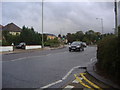
East End Road, East Finchley
This used to be the Manor Cottage roundabout with the North Circular Road, but was closed around 1990 when it was widened and left out the junction here, with the Manor Cottage pub also being demolished for a block of flats. The road behind them used to be a field up to the 70s but is now Briar Close and a housing estate.
Image: © David Howard
Taken: 12 Sep 2008
0.04 miles
10
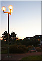
Marie Curie Cancer Care Garden of Hope
View of the garden at dusk. Discarded super brew cans adorn the bench. The houses beyond are on Tangle Tree Close.
Image: © Martin Addison
Taken: 22 Aug 2008
0.05 miles