IMAGES TAKEN NEAR TO
The Leys, LONDON, N2 0HE
Introduction
This page details the photographs taken nearby to The Leys, N2 0HE by members of the Geograph project.
The Geograph project started in 2005 with the aim of publishing, organising and preserving representative images for every square kilometre of Great Britain, Ireland and the Isle of Man.

There are currently over 7.5m images from over14,400 individuals and you can help contribute to the project by visiting https://www.geograph.org.uk
Image Map
Images are licensed for reuse under creativecommons.org/licenses/by-sa/2.0
Notes
- Clicking on the map will re-center to the selected point.
- The higher the marker number, the further away the image location is from the centre of the postcode.
Image Listing (399 Images Found)
Images are licensed for reuse under creativecommons.org/licenses/by-sa/2.0
Image
Details
Distance
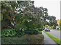
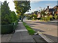
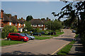
1
The Leys
A short cul-de-sac off Brim Hill in Hampstead Garden Suburb.
Image: © Martin Addison
Taken: 1 Oct 2008
0.03 miles
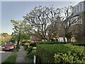
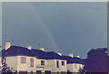
5
Maya Road
Landscaped garden in East Finchley. Area was a playing field until the 1980s when houses were built on it.
Image: © David Howard
Taken: 31 May 2006
0.05 miles
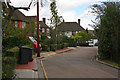
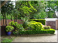
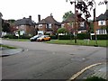
7
Brim Hill
At the junction with Greenhalgh Walk (on the right).
Image: © Martin Addison
Taken: 30 Aug 2008
0.05 miles
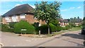
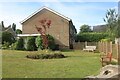
8
Brim Hill at the junction of Greenhalgh Walk
Image: © David Howard
Taken: 11 May 2020
0.05 miles