IMAGES TAKEN NEAR TO
N20 9WD
Introduction
This page details the photographs taken nearby to N20 9WD by members of the Geograph project.
The Geograph project started in 2005 with the aim of publishing, organising and preserving representative images for every square kilometre of Great Britain, Ireland and the Isle of Man.

There are currently over 7.5m images from over14,400 individuals and you can help contribute to the project by visiting https://www.geograph.org.uk
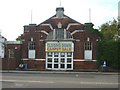
Image Map
Images are licensed for reuse under creativecommons.org/licenses/by-sa/2.0
Notes
- Clicking on the map will re-center to the selected point.
- The higher the marker number, the further away the image location is from the centre of the postcode.
Image Listing (85 Images Found)
Images are licensed for reuse under creativecommons.org/licenses/by-sa/2.0
Image
Details
Distance
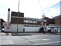
2
Former postal sorting office, Whetstone, London N20
Image: © Jim Osley
Taken: 8 Aug 2010
0.03 miles
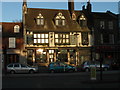
4
The Griffin
Popular Whetstone pub that dates back to 1697, it was catering for waggoners by the early 1800's, (Information from British History Online). Once a Fullers house, it has been an Irish theme pub and is now a Firkin house.
Image: © Martin Addison
Taken: 6 Apr 2007
0.04 miles
5
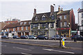
Whetstone High Road
The pub in this picture is the Griffin, which dates from 1928 although there has been an inn on this site in the centre of Whetstone for much longer.
Image: © Stephen McKay
Taken: 6 Feb 2017
0.04 miles
6
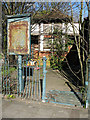
Disused Public Convenience
Opposite the council offices in Barnet House is this neglected piece of civic architecture. It must once have been a symbol of civic pride, finished in a half-timbered style. The trees might come in handy if you need to spend a penny!
Subsequent to this photo being taken, in September 2009 it was noted that these toilets and the adjacent building have been demolished and the site cleared.
Image: © Martin Addison
Taken: 6 Apr 2007
0.04 miles
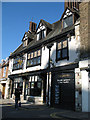
7
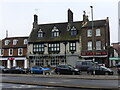
The Griffin Inn Whetstone
The Griffin prospers as a gastro pub on Whetstone High Road, once the Great North Road. It was a Coaching Inn originally from the seventeenth century I understand. Diagonally opposite it to the camera's right and out of picture is the soon to be demolished 1960's concrete office block that has become an eyesore. I have also uploaded a photo of that building. That the old building survives and the new one goes under perhaps is the exception to the economic rule of creative destruction as expounded by Joseph Schumpeter to explain the workings of capitalism.
In front of the blue car in the photo the horse trough is not original and the 'whetstone' was no such thing. Perhaps it's creative heritage capitalism?
Image: © John Kingdon
Taken: 18 Jan 2022
0.04 miles
8
The Griffin public house, Whetstone
On High Road N20.
Image: © JThomas
Taken: 3 Sep 2016
0.05 miles
9
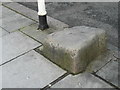
The whetstone outside the Griffin Public House, Whetstone
It is thought that this stone may have been used to sharpen knives etc in the past or was used as a mounting block outside the Griffin which was a coaching inn
Image: © Ken Amphlett
Taken: 7 Feb 2014
0.05 miles
10
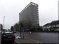
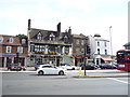
The (onetime) Ever Ready office block Whetstone
This decaying early 1960's concrete office block was once the proud Ever Ready Batteries' office building. Lately it was a Barnet Council office but now it is empty and ready for demolition. It looks old and tired and an eyesore. My father took a photo of it in 1966 and it was then clean and bright and doubtless seen as cutting edge for the time. Today it seems like an embarrassing reminder of a failed dream. I doubt it will be missed.
Image: © John Kingdon
Taken: 18 Jan 2022
0.06 miles