IMAGES TAKEN NEAR TO
Great Bushey Drive, LONDON, N20 8QL
Introduction
This page details the photographs taken nearby to Great Bushey Drive, N20 8QL by members of the Geograph project.
The Geograph project started in 2005 with the aim of publishing, organising and preserving representative images for every square kilometre of Great Britain, Ireland and the Isle of Man.

There are currently over 7.5m images from over14,400 individuals and you can help contribute to the project by visiting https://www.geograph.org.uk
Image Map
Images are licensed for reuse under creativecommons.org/licenses/by-sa/2.0
Notes
- Clicking on the map will re-center to the selected point.
- The higher the marker number, the further away the image location is from the centre of the postcode.
Image Listing (93 Images Found)
Images are licensed for reuse under creativecommons.org/licenses/by-sa/2.0
Image
Details
Distance
1
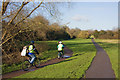
Cycling Along the Dollis Valley
A cycle path runs alongside Dollis Brook and the Dollis Valley Green Walk through Brook Farm Open Space.
Image: © Martin Addison
Taken: 6 Dec 2008
0.07 miles
2
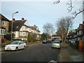
Dollis Valley Greenwalk
Taken just north of Totteridge & Whetstone station. The Greenwalk follows the course of the Dollis Brook between Hampstead Garden Suburb and Moat Mount Open Space north of Mill Hill, passing through some surprisingly rural areas en route.
Image: © David Kemp
Taken: 12 May 2010
0.08 miles
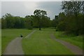
3
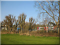
Brook Farm open space
The Dollis Valley Greenwalk and a parallel cycleway head north along the valley of the Dollis Brook, which is in the shadow on the left.
Image: © Robin Webster
Taken: 25 Nov 2012
0.09 miles
5
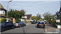
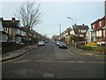
Oak Tree Drive, Totteridge
A quiet residential street in Totteridge.
Image: © Peter Mackenzie
Taken: 10 Sep 2019
0.09 miles
7
Totteridge Departure
A Northern Line train pulls out of Totteridge and Whetstone Station for High Barnet. The foreground trees have been hacked back, making their appearance ugly. The white building in the background is Northway House.
Image: © Martin Addison
Taken: 1 Apr 2007
0.11 miles
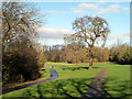
8
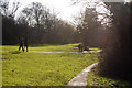
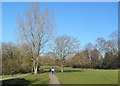
Lovers and Joggers
A couple holding hands and a brace of joggers make tracks towards Totteridge Lane on the Dollis Valley Green Walk. The slope of the ground towards the Brook, which is out of shot on the right, is evident in this photo.
Image: © Martin Addison
Taken: 6 Dec 2008
0.11 miles
9
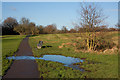
Brook Farm Open Space
A number of small streams cross the open land carrying water down to Dollis Brook. In winter much of the ground becomes waterlogged and mini lakes form. The water then finds its own way down the side of the valley to the brook. There is a stream going through pipes under the path where the clump of vegetation is on the right.
Image: © Martin Addison
Taken: 6 Dec 2008
0.11 miles
10
Dollis Valley Greenwalk
A path which lives up to its name, following a corridor of park and woodland beside the Dollis Brook through busy suburbs on each side.
Image: © Des Blenkinsopp
Taken: 26 Feb 2019
0.11 miles