IMAGES TAKEN NEAR TO
Totteridge Village, LONDON, N20 8PS
Introduction
This page details the photographs taken nearby to Totteridge Village, N20 8PS by members of the Geograph project.
The Geograph project started in 2005 with the aim of publishing, organising and preserving representative images for every square kilometre of Great Britain, Ireland and the Isle of Man.

There are currently over 7.5m images from over14,400 individuals and you can help contribute to the project by visiting https://www.geograph.org.uk
Image Map
Images are licensed for reuse under creativecommons.org/licenses/by-sa/2.0
Notes
- Clicking on the map will re-center to the selected point.
- The higher the marker number, the further away the image location is from the centre of the postcode.
Image Listing (73 Images Found)
Images are licensed for reuse under creativecommons.org/licenses/by-sa/2.0
Image
Details
Distance
1
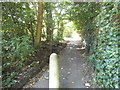
Footpath From Totteridge
This footpath leads from Totteridge Village across the Dollis Valley to Leeside in Barnet.
Image: © Martin Addison
Taken: 19 Apr 2011
0.01 miles
3
Barnet Lane, Totteridge
Looking north-west to junction with White Orchards, near Totteridge Village
Image: © David Hawgood
Taken: 5 Mar 2006
0.08 miles
5
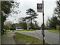
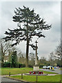
Totteridge war memorial
The memorial is on a grass triangle at the road junction together with a tall coniferous tree. The near bus stop is named after the memorial, and serves route 251 towards Whetstone, together with some school services.
Image: © Robin Webster
Taken: 21 Mar 2013
0.09 miles
6
War memorial, Totteridge
A grade II listed 'building'.
Image: © Robin Webster
Taken: 21 Mar 2013
0.09 miles

9
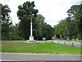
Totteridge: The War Memorial
The slender and elegant War Memorial is on a green triangle of land at the main road junction in Totteridge, where Barnet Lane joins with the A5109 road, here known as Totteridge Village.
Image: © Nigel Cox
Taken: 8 Sep 2008
0.10 miles
10
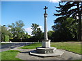
Totteridge War Memorial
In Nairn's London (1966) Ian Nairn says of Totteridge: "More of a phenomenon than a village. It is a ridge-back, south-west of Barnet, and the views are green in both directions. Totteridge village, at the east end of the ridge, is restrained, expensive, and not really remarkable except for the sweet weatherboarded tower of the church, built 1790 and not looking a day over eighteen."
The war memorial is on a small green to the north of the church where Barnet Lane meets the A5109 (Totteridge Village).
Image: © Marathon
Taken: 5 Oct 2016
0.10 miles