IMAGES TAKEN NEAR TO
Elkanette Mews, LONDON, N20 0PF
Introduction
This page details the photographs taken nearby to Elkanette Mews, N20 0PF by members of the Geograph project.
The Geograph project started in 2005 with the aim of publishing, organising and preserving representative images for every square kilometre of Great Britain, Ireland and the Isle of Man.

There are currently over 7.5m images from over14,400 individuals and you can help contribute to the project by visiting https://www.geograph.org.uk
Image Map
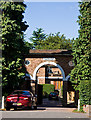
Images are licensed for reuse under creativecommons.org/licenses/by-sa/2.0
Notes
- Clicking on the map will re-center to the selected point.
- The higher the marker number, the further away the image location is from the centre of the postcode.
Image Listing (80 Images Found)
Images are licensed for reuse under creativecommons.org/licenses/by-sa/2.0
Image
Details
Distance
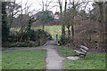
1
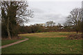
Whetstone Stray
Looking towards Whetstone itself with 1255 High Road, Barnet's council offices, visible through the trees. The footpath forms part of the Dollis Valley Green Walk.
Image: © Martin Addison
Taken: 20 Feb 2009
0.10 miles
5
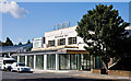
N20
A restaurant and bar occupying the offices of an old car showroom on the High Road in Whetstone. The car showroom itself is undergoing some building work at present and I wait to see what it will become.
Image: © Martin Addison
Taken: 5 Sep 2009
0.13 miles
6

Whetstone Audi
A large modern car showroom, presumably in keeping with the company's vorsprung durch technik slogan. The High Road begins to widen here, becoming a short stretch of dual carriageway as it approaches the centre of Whetstone - quite why is a bit of a mystery.
Image: © Martin Addison
Taken: 5 Sep 2009
0.14 miles
7
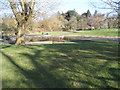
Bridge Over Dollis Brook
The footbridge connects both sides of Whetstone Stray. The houses beyond are on Longland Drive.
Image: © Martin Addison
Taken: 20 Feb 2009
0.14 miles
8
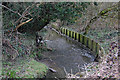
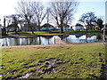
Dollis Brook
Seen here as it passes through Whetstone Stray. The wooden boards help to prevent further erosion of the bank.
Image: © Martin Addison
Taken: 20 Feb 2009
0.15 miles
9
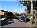
Ridgeview Road
Seen from the junction with Charnwood Place. The white office block in the distance is Northway House on the High Road, Whetstone. Closer views of Northway House can be found at Image and Image by myself and Alasdair Addison respectively.
Image: © Martin Addison
Taken: 20 Feb 2009
0.15 miles
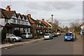
10
1071 High Road
Evidence that we are in Whetstone. An unusual housing development, breaking from the terraced and semi-detached norm of the area. Apartments are arranged around 3 sides of a courtyard with trees on the 4th and parking in the centre.
Image: © Martin Addison
Taken: 5 Sep 2009
0.15 miles