IMAGES TAKEN NEAR TO
Princess May Road, LONDON, N16 8DF
Introduction
This page details the photographs taken nearby to Princess May Road, N16 8DF by members of the Geograph project.
The Geograph project started in 2005 with the aim of publishing, organising and preserving representative images for every square kilometre of Great Britain, Ireland and the Isle of Man.

There are currently over 7.5m images from over14,400 individuals and you can help contribute to the project by visiting https://www.geograph.org.uk
Image Map
Images are licensed for reuse under creativecommons.org/licenses/by-sa/2.0
Notes
- Clicking on the map will re-center to the selected point.
- The higher the marker number, the further away the image location is from the centre of the postcode.
Image Listing (134 Images Found)
Images are licensed for reuse under creativecommons.org/licenses/by-sa/2.0
Image
Details
Distance
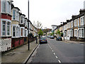
1
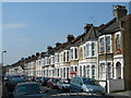
Princess May Road, N16
A typical Stoke Newington side street.
Image: © Danny P Robinson
Taken: 1 Apr 2007
0.01 miles
2
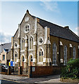
Church of God World Fellowship, Barrett's Grove, Stoke Newington
Former Welsh Congregational Chapel of c. 1884.
Image: © Jim Osley
Taken: 7 Sep 2017
0.03 miles
4
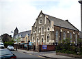
Hackney (southern fringes): Church of God (World Fellowship),Barrett's Grove
The datestone reads '1985', but I interpret this as being the date of refurbishment by the present owners. There is no church marked here on the OS map, but it looks Victorian.
Image: © Dr Neil Clifton
Taken: 1 May 2012
0.05 miles
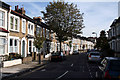
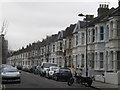
6
Hackney (southern fringes): Barrett's Grove
Looking west from about halfway along.
Image: © Dr Neil Clifton
Taken: 1 May 2012
0.07 miles
7

St Paul's Church, Stoke Newington Road - Wall painting
Image: © John Salmon
Taken: 12 May 2011
0.07 miles
8
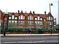
Hackney southern fringe: Princess May Primary School
Typical LCC school building, of which there are quite a few still in use: They have stood the test of time well. Playground full of happy-looking active kids.
Image: © Dr Neil Clifton
Taken: 1 May 2012
0.07 miles
10
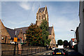
Stoke Newington: St. Matthias Church
I understand that this church,built around 1850, was virtually flattened by the Luftwaffe during World War II, but rebuilt to the original pattern in the 1950s. I believe it has Grade I Listed status, but I can't really see why, the exterior showing little of interest apart from the massive tall tower.
Image: © Dr Neil Clifton
Taken: 7 Oct 2010
0.07 miles