1
Hackney (southern fringes): Barrett's Grove
Looking west from about halfway along.
Image: © Dr Neil Clifton
Taken: 1 May 2012
0.01 miles
2
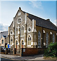
Hackney (southern fringes): Church of God (World Fellowship),Barrett's Grove
The datestone reads '1985', but I interpret this as being the date of refurbishment by the present owners. There is no church marked here on the OS map, but it looks Victorian.
Image: © Dr Neil Clifton
Taken: 1 May 2012
0.04 miles
3
Stoke Newington: St. Matthias Church
I understand that this church,built around 1850, was virtually flattened by the Luftwaffe during World War II, but rebuilt to the original pattern in the 1950s. I believe it has Grade I Listed status, but I can't really see why, the exterior showing little of interest apart from the massive tall tower.
Image: © Dr Neil Clifton
Taken: 7 Oct 2010
0.04 miles
4
Corner Cafe, Stoke Newington
Cafe on the corner of Matthias Road and Wordsworth Road.
Image: © Stephen McKay
Taken: 15 May 2009
0.04 miles
5
Stoke Newington: St. Matthias Church of England Primary School
Image: © Dr Neil Clifton
Taken: 7 Oct 2010
0.04 miles
6
Church of God World Fellowship, Barrett's Grove, Stoke Newington
Former Welsh Congregational Chapel of c. 1884.
Image: © Jim Osley
Taken: 7 Sep 2017
0.04 miles
7
Stoke Newington: Barrett Grove
Image: © Dr Neil Clifton
Taken: 7 Oct 2010
0.05 miles
8
St Matthias Church, Stoke Newington
Grade I listed church on Wordsworth Road.
See http://www.britishlistedbuildings.co.uk/en-426310-church-of-st-matthias-greater-london-aut for more details about the listed church.
Image: © David Anstiss
Taken: 3 Feb 2013
0.05 miles
9
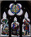
St Matthias, Stoke Newington - Stained glass window
Image: © John Salmon
Taken: 29 Oct 2014
0.05 miles
10
Stoke Newington: The 'Arundel Arms', Boleyn Road
Another of London's pubs that has served its last pint. I don't know the identity of the rascally individual portrayed on the sign.
Image: © Dr Neil Clifton
Taken: 7 Oct 2010
0.05 miles


