IMAGES TAKEN NEAR TO
Bathurst Square, LONDON, N15 4FW
Introduction
This page details the photographs taken nearby to Bathurst Square, N15 4FW by members of the Geograph project.
The Geograph project started in 2005 with the aim of publishing, organising and preserving representative images for every square kilometre of Great Britain, Ireland and the Isle of Man.

There are currently over 7.5m images from over14,400 individuals and you can help contribute to the project by visiting https://www.geograph.org.uk
Image Map
Images are licensed for reuse under creativecommons.org/licenses/by-sa/2.0
Notes
- Clicking on the map will re-center to the selected point.
- The higher the marker number, the further away the image location is from the centre of the postcode.
Image Listing (81 Images Found)
Images are licensed for reuse under creativecommons.org/licenses/by-sa/2.0
Image
Details
Distance
1
NEW
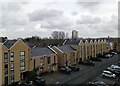
New housing off Lawrence Street, N15
Built on the site of former small industrial units
Image: © Bikeboy
Taken: 22 Feb 2025
0.03 miles
2
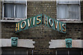
"Hovis" sign, Philip Lane, South Tottenham
Image: © Jim Osley
Taken: 26 Feb 2013
0.10 miles
3
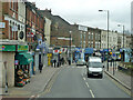
A504 West Green Road
Looking east from a bus.
Image: © Robin Webster
Taken: 5 Feb 2011
0.10 miles
4
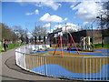
Playground in Elizabeth Place
This small playground brightens up the open space between Elizabeth Place and Clyde Road.
Image: © Marathon
Taken: 31 Mar 2015
0.11 miles
5
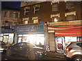
Shops on West Green Road, South Tottenham
Image: © David Howard
Taken: 8 Dec 2016
0.12 miles
6
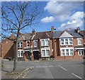
Clyde Circus
Clyde Circus is seen here from Clyde Road. Clyde Circus has a circular group of houses in the middle with small back gardens and what looks like a central communal area.
The central feature is Clyde Circus itself laid out in the late 18th century as the centre piece of a grand approach from Tottenham Green to the east to the former Downhills House to the west. The very interesting Haringey Council web site about the Conservation Area (of which Clyde Circus is the centre piece) has a series of Ordnance Survey Maps which show that although the Circus was here much earlier the houses were not built at the time of the 1894-96 Ordnance Survey Map but appeared on the 1915 Ordnance Survey Map.
Image: © Marathon
Taken: 31 Mar 2015
0.13 miles
7
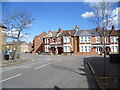
Clyde Circus
Clyde Circus is seen here from Clyde Road. Clyde Circus has a circular group of houses in the middle with small back gardens and what looks like a central communal area.
The central feature is Clyde Circus itself laid out in the late 18th century as the centre piece of a grand approach from Tottenham Green to the east to the former Downhills House to the west. The very interesting Haringey Council web site about the Conservation Area (of which Clyde Circus is the centre piece) has a series of Ordnance Survey Maps which show that although the Circus was here much earlier the houses were not built at the time of the 1894-96 Ordnance Survey Map but appeared on the 1915 Ordnance Survey Map.
Image: © Marathon
Taken: 31 Mar 2015
0.13 miles
8
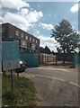
Turner Avenue Estate N15
Taken on a blazing hot day with temperatures up to 31 degrees centigrade. This photo shows block D of the 1950's council estate to the left and, to the right, the works entrance to Brunel Walk where new council homes are being constructed on the site of the now demolished 1970's substandard council homes. My photo {{{7812983}}} shows the other works entrance to the Brunel Walk site.
The neglected state of the pavement and grass show poor maintenance of the existing estate although the buildings are in good condition.
Image: © John Kingdon
Taken: 11 Aug 2024
0.16 miles
9
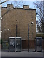
Lawrence Road London N15 Multiple Phone Boxes
Before I took the photo I checked and found all three phone boxes were still functioning. I can't imagine that even one would get enough use, if any, in this day and age in London. The boxes are not even of any historic or design significance and I wonder why they survive.
Image: © John Kingdon
Taken: 9 Feb 2023
0.16 miles
10
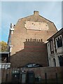
Advertising Molding on The Botany Bay pub (as was)
The Botany Bay pub (once the Greyhound) is now a supermarket with flats above. The old molded advertising board has been punctured by two central heating gas boiler vents and the remains of three light fittings hang on but cannot, and have nothing to, illuminate below them. The shadows of the neighbouring chimney pots add to the sense of decay.
Image: © John Kingdon
Taken: 31 Oct 2023
0.16 miles