IMAGES TAKEN NEAR TO
Waldeck Road, LONDON, N15 3EP
Introduction
This page details the photographs taken nearby to Waldeck Road, N15 3EP by members of the Geograph project.
The Geograph project started in 2005 with the aim of publishing, organising and preserving representative images for every square kilometre of Great Britain, Ireland and the Isle of Man.

There are currently over 7.5m images from over14,400 individuals and you can help contribute to the project by visiting https://www.geograph.org.uk
Image Map
Images are licensed for reuse under creativecommons.org/licenses/by-sa/2.0
Notes
- Clicking on the map will re-center to the selected point.
- The higher the marker number, the further away the image location is from the centre of the postcode.
Image Listing (104 Images Found)
Images are licensed for reuse under creativecommons.org/licenses/by-sa/2.0
Image
Details
Distance
1
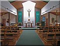
Christ Church with St Peter, Waldeck Road, London N15 - East end
Built 1982, architect Riley & Glanfield
Image: © John Salmon
Taken: 24 Jan 2008
0.01 miles
2
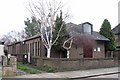
Christ Church with St Peter, Waldeck Road, London N15
Built 1982, architect Riley & Glanfield
Image: © John Salmon
Taken: 24 Jan 2008
0.02 miles
3
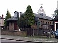
Christ Church with St Peter, Waldeck Road, London N15
Built 1982, architect Riley & Glanfield
Image: © John Salmon
Taken: 24 Jan 2008
0.02 miles
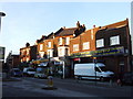
4

Langham Road, South Tottenham
From the end of Waldeck Road
Image: © David Howard
Taken: 25 Jun 2014
0.07 miles
6

Stanmore Road at the junction of Waldeck Road, N15
Image: © David Howard
Taken: 25 Jun 2014
0.09 miles
7
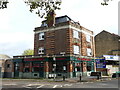
The Green Gate Pub (now closed)
The Green Gate was a fairly ordinary pub that had a make over just before covid struck and although looking like it was ready to re-emerge as a pub restaurant has never re-opened. There was once a five bar gate, painted green, attached to the wall to the left of the Willow Way road sign but that has now gone. The building itself is a lovely piece of pub architecture and I wonder what its fate will be.
Image: © John Kingdon
Taken: 9 Nov 2023
0.11 miles
8
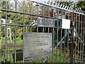
Mannock Road Allotments Fortified Gate
The Haringey Council signs are almost unreadable now but the 'danger' sign tells us rather starkly that the allotments are a 'hazardous area' and that the allotment management and tenants will not be liable for death or injury on the premises. I wonder if the new anti-climb razor devices on top of the gates might be the likely cause of death or are necessary to keep folk out of a deeply hazardous allotment. What has happened to our vegetable patches?
Image: © John Kingdon
Taken: 9 Nov 2023
0.11 miles
9
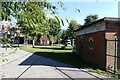
View Down Ivatt Way N17
The housing in the centre of the photo sits on the old railway alignment and there is now a footpath between Langham Road and Downhills Park Road where once a footbridge crossed the line. The two sets of rails embedded in the pathway are fakes: they are far too wide for the UK standard gauge tracks that once sat there. The artwork on the wall of the electricity substation gives a nod to a bygone age but strikes me at kitsch.
Image: © John Kingdon
Taken: 16 Sep 2024
0.11 miles
10
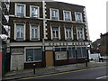
The Duke of Cambridge pub (as was)
This pub was renamed as the Golden Sands Bar shortly before the covid pandemic struck. It was then shut and has not reopened. I thought it would have been demolished to make way for flats as have the adjoining buildings. It should be noted however that work on the concrete structure to its left has been stopped for the last half year and so its advertised promise to provide forty six Council rented homes "soon" seems as empty as the old pub.
Image: © John Kingdon
Taken: 15 Apr 2023
0.12 miles