IMAGES TAKEN NEAR TO
Fairfield Close, LONDON, N12 9ST
Introduction
This page details the photographs taken nearby to Fairfield Close, N12 9ST by members of the Geograph project.
The Geograph project started in 2005 with the aim of publishing, organising and preserving representative images for every square kilometre of Great Britain, Ireland and the Isle of Man.

There are currently over 7.5m images from over14,400 individuals and you can help contribute to the project by visiting https://www.geograph.org.uk
Image Map (Loading...)


Getting Data...Please wait
Leaflet Map data © OpenStreetMap
Images are licensed for reuse under creativecommons.org/licenses/by-sa/2.0
Notes
- Clicking on the map will re-center to the selected point.
- The higher the marker number, the further away the image location is from the centre of the postcode.
Image Listing (65 Images Found)
Images are licensed for reuse under creativecommons.org/licenses/by-sa/2.0
Image
Details
Distance
1
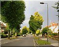
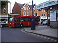
Ravensdale Avenue, North Finchley
Typical 1930's suburban residential development - of a kind that could be matched in many outer London boroughs. The curious lollipop-shaped trees caught my eye - limes, I think.
Image: © Stefan Czapski
Taken: 6 Jul 2014
0.07 miles
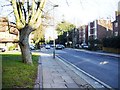
3
North Finchley library
On Ravensdale Avenue, just off the High Road.
Image: © Robin Webster
Taken: 6 Apr 2013
0.08 miles
4
Old Milepost
Old milepost at North Finchley for overall view see http://www.geograph.org.uk/photo/3635114
Image: © Keith Evans
Taken: 3 Sep 2013
0.09 miles
5
Woodside Park Road, junction with North Finchley High Road
Image: © David Howard
Taken: 7 Sep 2007
0.09 miles
6
Old Milepost
Old milepost at North Finchley for close up view see http://www.geograph.org.uk/photo/3635102
Image: © Keith Evans
Taken: 3 Sep 2013
0.09 miles
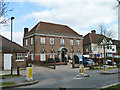
7
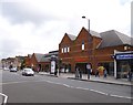
North Finchley, Sainsbury's
On Whetstone High Road.
Image: © Mike Faherty
Taken: 4 Aug 2012
0.09 miles
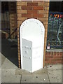
8
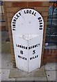
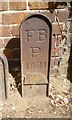
Old Milepost by the A1000, High Road, North Finchley
Cast iron post by the A1000, in parish of FINCHLEY (BARNET District), High Road, North Finchley, N12. Beside Sainsbury supermarket (Nos. 842 and 844), south of Ravensdale Avenue, in pavement slabs with back to wall, to left of shop front, on East side of road. Erected by the Local Highways Board in the 19th century.
Inscription reads:-
: LONDON / 8 / MILES : : FINCHLEY LOCAL BOARD : : BARNET / 3 / MILES :
Grade II listed.
List Entry Number: 1064902 https://historicengland.org.uk/listing/the-list/list-entry/1064902
Milestone Society National ID: MX_LY08.
Image: © JR Dowding
Taken: 14 Jun 2003
0.10 miles
9
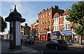
Shops on the High Road
A disparate group of buildings on the west side of the High Road. The Amber Gallery, an art and jewellery dealer located in the centre of the photo has an archway leading through to a courtyard behind. Several other buildings along this stretch of the road have similar courtyards. The road between the shops, just left of centre, is Woodside Park Road.
Image: © Martin Addison
Taken: 3 Oct 2008
0.10 miles
10
Old Boundary Marker by Torrington Park, Finchley Parish
Parish Boundary Marker by the UC road, in parish of Finchley (Barnet District), Woodhouse Road N12, Next to No 44, by stench pipe and letterbox against modern wall. Adjacent to: MX_FINC01pb Image
Inscription reads:-
FB
P
1871
Surveyed
Milestone Society National ID: MX_FBAR01pb
Image: © Milestone Society
Taken: Unknown
0.11 miles