IMAGES TAKEN NEAR TO
Chanctonbury Way, LONDON, N12 7AB
Introduction
This page details the photographs taken nearby to Chanctonbury Way, N12 7AB by members of the Geograph project.
The Geograph project started in 2005 with the aim of publishing, organising and preserving representative images for every square kilometre of Great Britain, Ireland and the Isle of Man.

There are currently over 7.5m images from over14,400 individuals and you can help contribute to the project by visiting https://www.geograph.org.uk
Image Map
Images are licensed for reuse under creativecommons.org/licenses/by-sa/2.0
Notes
- Clicking on the map will re-center to the selected point.
- The higher the marker number, the further away the image location is from the centre of the postcode.
Image Listing (37 Images Found)
Images are licensed for reuse under creativecommons.org/licenses/by-sa/2.0
Image
Details
Distance
1
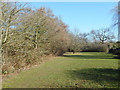
Field in Woodside Park
A long strip of grassy meadow beside a small tributary of the Dollis Brook. No doubt kept clear because of flooding.
Image: © Des Blenkinsopp
Taken: 26 Feb 2019
0.02 miles
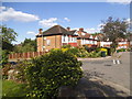
2
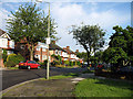
Chanctonbury Way
Seen from the junction with Southover Way.
Image: © Martin Addison
Taken: 29 May 2007
0.08 miles
5
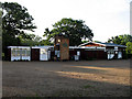
Old Finchleians Memorial Ground
View of the clubhouse which also finds use as a pre-school centre.
Image: © Martin Addison
Taken: 29 May 2007
0.11 miles
6
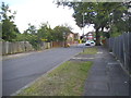
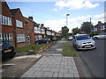
Cissbury Ring North at the junction of Scaynes Link
Image: © David Howard
Taken: 5 Jun 2014
0.12 miles

8
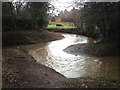
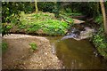
Dollis Brook
View of Dollis Brook looking south from Old Finchleians Memorial Ground, woodside Park. In the foreground is a tributary that flows down from the fields behind Totteridge Common. The main brook enters the picture from the left.
Image: © Martin Addison
Taken: 15 Feb 2006
0.14 miles
9
Dollis Brook, Woodside Park
Here it branches to a little stream on the left going into Totteridge.
Image: © David Howard
Taken: 22 Sep 2021
0.16 miles
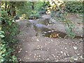
10
Confluence of the Folly and Dollis Brooks, Woodside Park
This is the point where the 3.6km long Folly Brook runs into the Dollis Brook.
Image: © Jim Osley
Taken: 12 Mar 2011
0.16 miles