1
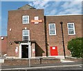
Royal Mail sorting office at North Finchley
The sorting office is viewed across Lodge Lane near the junction with Gainsborough Road.
Image: © Marathon
Taken: 7 Sep 2016
0.02 miles
2
Cottages on Lodge Lane
The first cottages were built on Lodge Lane in the early 1820's. North Finchley's first shops were also located on Lodge Lane. Private John Parr, first British soldier killed in World War I, and David Jason (Actor) both lived in this road. Information from Wikipedia.
Image: © Martin Addison
Taken: 16 Oct 2006
0.05 miles
3
North Finchley Sorting Office
Royal mail sorting office located on Lodge lane, North Finchley.
Image: © Martin Addison
Taken: 16 Oct 2006
0.05 miles
4
North Finchley Sorting Office
Looking through the gates into the compound. If it's metal, paint it red. Even the private car parked inside seems to be the correct shade!
Image: © Martin Addison
Taken: 16 Oct 2006
0.05 miles
5
Cottages in North Finchley
There are a number of cottages and houses in the roads around here which date from when this was a country village. This row of houses is in Lodge Lane.
More about the history of North Finchley and these cottages can be found at https://en.wikipedia.org/wiki/History_of_North_Finchley
Image: © Marathon
Taken: 7 Sep 2016
0.09 miles
6
Percy Road N12
Terraced housing at the west end of Percy Road, where it connects with Church Path. The houses in the centre sit at an unusual angle to each other, presumably to deal with the bend in the road. The sun has yet to burn off the mist on this chilly October morning.
Image: © Martin Addison
Taken: 16 Oct 2006
0.10 miles
7
Church Path N12
Terraced houses on Church Path by the junction with Percy Road. Beyond can be seen the alleyway section of Church Path leading onto Lodge Lane. The Building beyond the Pink house is industrial.
Image: © Martin Addison
Taken: 16 Oct 2006
0.10 miles
8
Church Path N12
Looking along Church Path from the Netherfield Road end towards its junction with Percy Road where the alleyway opens out into a cul-de-sac with houses before becoming an alley once more as it continues to Lodge Lane. The lady pedestrian in the distance is on the section leading to Lodge Lane. Church Path continues north from Lodge lane until it connects with the High Road in the vicinity of The Swan and Pyramids public house.
Image: © Martin Addison
Taken: 16 Oct 2006
0.10 miles
9
Woodside Park Road
Image: © Colin Pyle
Taken: 2 Jul 2011
0.11 miles
10
New flats above shops, Lodge Lane
Image: © Alex McGregor
Taken: 19 Feb 2013
0.13 miles


