IMAGES TAKEN NEAR TO
Crescent Way, LONDON, N12 0RA
Introduction
This page details the photographs taken nearby to Crescent Way, N12 0RA by members of the Geograph project.
The Geograph project started in 2005 with the aim of publishing, organising and preserving representative images for every square kilometre of Great Britain, Ireland and the Isle of Man.

There are currently over 7.5m images from over14,400 individuals and you can help contribute to the project by visiting https://www.geograph.org.uk
Image Map
Images are licensed for reuse under creativecommons.org/licenses/by-sa/2.0
Notes
- Clicking on the map will re-center to the selected point.
- The higher the marker number, the further away the image location is from the centre of the postcode.
Image Listing (38 Images Found)
Images are licensed for reuse under creativecommons.org/licenses/by-sa/2.0
Image
Details
Distance
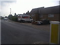
3
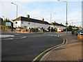
Summers Lane
Council Housing - probably all now private houses - on Summers Lane. The roundabout is located on the junction with the road to the civic amenity and recycling centre. It looks like there is a handy neighbour if your car won't start.
Image: © Martin Addison
Taken: 11 Aug 2006
0.10 miles
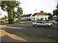
4
Crescent Way from Ingleway, North Finchley
Image: © David Howard
Taken: 29 May 2012
0.11 miles
5
Summers Lane at the junction to the civic amenity site
The local rubbish dump is the only one in Barnet borough since they closed the other one near Brent Cross. Being at the eastern end of the borough means people on the other side now have some way to travel to get there.
Image: © David Howard
Taken: 29 May 2012
0.11 miles
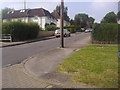
6
Ingleway
Part of the housing estate between Summers Lane and Woodhouse Road. The roundabout is a bit of a mystery - there is no junction, just a rightangle bend!
Image: © Martin Addison
Taken: 11 Aug 2006
0.13 miles
7
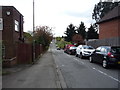
Crescent Way
Looking south from Woodhouse Road.
Image: © JThomas
Taken: 23 Apr 2016
0.14 miles
8
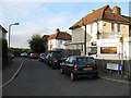
Downway or Summers Lane
Opposite Upway, off Summers Lane, and leading to Legion Way, which is a cul-de-sac. The road name, Downway, is not displayed although it does appear on some maps - other maps show this as Summers Lane. The houses are numbered as being on Summers Lane, though the road signs disagree about which house numbers are involved. The blocks of flats in the distance are in Prospect Ring and Park Road, East Finchley.
Image: © Martin Addison
Taken: 11 Aug 2006
0.14 miles
9
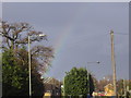
Rainbow over Summers Lane, North Finchley
Image: © David Howard
Taken: 26 Mar 2009
0.15 miles
10
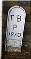
Old Boundary Marker by Hilton Avenue, Finchley Parish
Parish Boundary Marker by the UC road, in parish of Finchley (Barnet District), Hilton Avenue N12, next to Woodhouse College entrance against wall.
Adjacent to: MX_FINC02pb Image
Inscription reads:-
F B
P
1910
Surveyed
Milestone Society National ID: MX_FBAR02pb
Image: © Milestone Society
Taken: Unknown
0.16 miles