IMAGES TAKEN NEAR TO
Granville Place, High Road, LONDON, N12 0AX
Introduction
This page details the photographs taken nearby to Granville Place, High Road, N12 0AX by members of the Geograph project.
The Geograph project started in 2005 with the aim of publishing, organising and preserving representative images for every square kilometre of Great Britain, Ireland and the Isle of Man.

There are currently over 7.5m images from over14,400 individuals and you can help contribute to the project by visiting https://www.geograph.org.uk
Image Map (Loading...)


Getting Data...Please wait
Leaflet Map data © OpenStreetMap
Images are licensed for reuse under creativecommons.org/licenses/by-sa/2.0
Notes
- Clicking on the map will re-center to the selected point.
- The higher the marker number, the further away the image location is from the centre of the postcode.
Image Listing (66 Images Found)
Images are licensed for reuse under creativecommons.org/licenses/by-sa/2.0
Image
Details
Distance
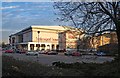
1
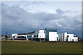
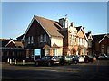
Finchley Memorial Hospital
The new hospital which was completed in October 2012 and officially opened on 12th September 2013 by His Royal Highness the Duke of Gloucester.
Image: © Martin Addison
Taken: 26 Mar 2014
0.06 miles
2
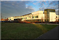
Finchley Memorial Hospital
Officially opened in 2013. Built to the designs of architects Murphy Philipps.
Image: © Jim Osley
Taken: 18 Jan 2017
0.08 miles
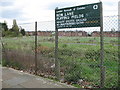
3
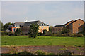
Bow Lane Playing Fields
Looking across the fields towards the apartment development on the Great North Road - the buildings were once a secondary school. The houses on the right are on Heatherdene Close. See Image for more information about Bow Lane Playing Fields.
Image: © Martin Addison
Taken: 20 Sep 2008
0.10 miles
4
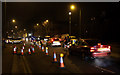
Saturday Night Jam
Traffic queues on the southbound A1000 at the junction with the entrance to the Finchley Lido complex due to roadworks reducing the width of the carriageway to a single lane. Lido employees were assisting the flow of traffic by preventing the junction from being blocked by inconsiderate drivers - which would have resulted in a tailback in the northbound direction as well.
Image: © Martin Addison
Taken: 6 Feb 2010
0.10 miles
5
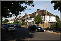
Bow Lane
Semi-detached housing in mock tudor style next to Bow Lane Playing Fields.
Image: © Martin Addison
Taken: 20 Sep 2008
0.10 miles
6
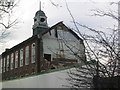
Finchley County School being demolished
I was a pupil at this school from 1949 - 1954 and watched its demolition in 2003
Image: © Ken Amphlett
Taken: 22 Dec 2003
0.11 miles
7
Bow Lane Playing Fields
Not a lot of playing gets done here - the gates are firmly locked with high security padlocks. The tarmac tennis courts are being taken over by trees and brambles. The grass is left to grow. A little piece of Camden in the London Borough of Barnet. Currently (2008) this site is linked with a complete redevelopment of Finchley Memorial Hospital. The flats in the distance are located on the west side of the High Road, (A1000).
Image: © Martin Addison
Taken: 2 May 2006
0.12 miles
8
Entertainment centre, Finchley
Bowling alley and cinema in the Great North Leisure Park.
Image: © Jim Osley
Taken: 18 Jan 2017
0.12 miles
9
Finchley Memorial Hospital
Finchley Memorial Hospital, Granville Road, N12. Founded in 1908 as Finchley Cottage Hospital, it was enlarged following the 1914-18 war and renamed as a memorial to the fallen.
Image: © Martin Addison
Taken: 9 Feb 2006
0.12 miles
10
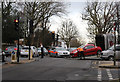
Clearing Up
A Police Officer directs traffic while a car is removed from the junction of Summers Lane with the High Road in Finchley following a minor accident. The Police BMW blocking the junction is an ex-Armed Response Unit vehicle now performing more standard policing duties - no need for guns but a dust pan and brush for the broken plastic might have come in handy!
Image: © Martin Addison
Taken: 7 Dec 2013
0.12 miles