IMAGES TAKEN NEAR TO
Glebelands Close, LONDON, N12 0AH
Introduction
This page details the photographs taken nearby to Glebelands Close, N12 0AH by members of the Geograph project.
The Geograph project started in 2005 with the aim of publishing, organising and preserving representative images for every square kilometre of Great Britain, Ireland and the Isle of Man.

There are currently over 7.5m images from over14,400 individuals and you can help contribute to the project by visiting https://www.geograph.org.uk
Image Map
Images are licensed for reuse under creativecommons.org/licenses/by-sa/2.0
Notes
- Clicking on the map will re-center to the selected point.
- The higher the marker number, the further away the image location is from the centre of the postcode.
Image Listing (80 Images Found)
Images are licensed for reuse under creativecommons.org/licenses/by-sa/2.0
Image
Details
Distance
1

Hollywood Bowl
The ten pin bowling alley, incorporating the Vue cinema, at the Finchley Lido complex on a cold clear February evening. Extensive parking facilities are provided.
Image: © Martin Addison
Taken: 9 Feb 2010
0.03 miles
2
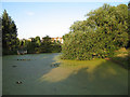
Glebelands Pond
Man-made pond at the western end of the Glebelands Local Nature Reserve. A Weeping Willow dips its leaves in the waters edge. A resident family of Moorhen's have left trails through the duck weed that conceals the surface. There are waterlillies, which have finished flowering for this year and, unfortunately, plastic bottles. In the distance is a parade of shops on Glebe Road.
Image: © Martin Addison
Taken: 10 Aug 2006
0.05 miles
3
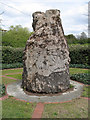
Stand and Deliver
On the edge of the Glebelands the bole of a dead tree has been carved to depict a highwayman. It forms a memento of the time when highwaymen frequently robbed travellers on the Great North Road as they crossed Finchley Common. Finchley's association with highwaymen is further recalled by 'The Dick Turpin' pub on Long Lane.
Image: © Martin Addison
Taken: 2 May 2006
0.05 miles
4

Footpath on the Glebeland
Two footpaths on the Glebeland. The main footpath leads from the A1000 to the Glebelands open space where Wingate & Finchley FC and Finchley RFC have their playing fields. The gateway on the left gives access to a footpath through the Glebelands local nature reserve. The Glebelands are commonly referred to locally as 'The rough Lots'.
Image: © Martin Addison
Taken: 2 May 2006
0.05 miles
5
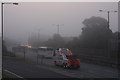
Fog on the A406
A Stansted bound coach and a recovery truck head east. The pink glow in the sky show that the sun has started to burn through the fog. The sign on the left refers to the layout of the junction at the top of the sliproad on the left. Its positioning leaves something to be desired as it could be misread as referring to the North Circular Road itself.
Image: © Martin Addison
Taken: 31 Aug 2008
0.06 miles
6

High Road, North Finchley
Looking towards junction of Bow Lane and Squires Lane on the left
Image: © David Howard
Taken: 7 Sep 2007
0.07 miles
7
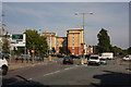
Squires Lane, Junction with A1000
The sign on the left indicates that at the end of Squires Lane motorists can join the A406. It makes no mention of the A1000 which is the road crossing right to left. The road on the left behind the sign is Bow Lane.
Image: © Martin Addison
Taken: 20 Sep 2008
0.07 miles
8

Night Emergency
An ambulance and a paramedic attending a night time emergency at an apartment block on High Road, Finchley. The bus stop makes a convenient location to pull off the road. Both crews are inside with the patient.
Image: © Martin Addison
Taken: 28 Jul 2010
0.07 miles
9
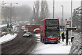
The Promised Snow Has Arrived
North London gets its first real snow of the 2012/13 winter. Traffic is light on the A1000 in this early afternoon view as a 263 drops passengers at the Squires Lane stop. The same cannot be said of the A406 passing below where the traffic is heavy eastbound.
Image: © Martin Addison
Taken: 18 Jan 2013
0.07 miles
10
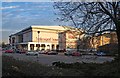
Entertainment centre, Finchley
Bowling alley and cinema in the Great North Leisure Park.
Image: © Jim Osley
Taken: 18 Jan 2017
0.08 miles