IMAGES TAKEN NEAR TO
Coppetts Close, LONDON, N12 0AG
Introduction
This page details the photographs taken nearby to Coppetts Close, N12 0AG by members of the Geograph project.
The Geograph project started in 2005 with the aim of publishing, organising and preserving representative images for every square kilometre of Great Britain, Ireland and the Isle of Man.

There are currently over 7.5m images from over14,400 individuals and you can help contribute to the project by visiting https://www.geograph.org.uk
Image Map
Images are licensed for reuse under creativecommons.org/licenses/by-sa/2.0
Notes
- Clicking on the map will re-center to the selected point.
- The higher the marker number, the further away the image location is from the centre of the postcode.
Image Listing (21 Images Found)
Images are licensed for reuse under creativecommons.org/licenses/by-sa/2.0
Image
Details
Distance
1
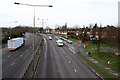
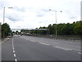
A406 - North Circular Road
View from the Coppetts Wood footbridge. Houses on Coppetts Close are visible on the right.
Image: © Martin Addison
Taken: 24 Feb 2011
0.02 miles
2
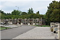
Burial chambers, Islington and St Pancras Cemeteries
On St David's Avenue, this is part of "St Pancras Cemetery Village".
Image: © Trevor Harris
Taken: 7 Sep 2016
0.07 miles
3
St. Pancras and Islington Cemetery
Seen from the Coppetts Wood footbridge over the A406, North Circular Road. The brick buildings in the distance are flats on the Strawberry Vale estate.
Image: © Martin Addison
Taken: 24 Feb 2011
0.09 miles
4
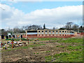
New mausoleum, Islington and Camden Cemeteries
Apparently still being finished.
Image: © Robin Webster
Taken: 6 Apr 2013
0.09 miles
5
North Circular Road The A406
Looking west along the dual carriageway from just west of the junction with the B550 Colney Hatch Lane. The footpath joins the area around Colney Hatch Nature Reserve to the north with the area round St Pancras and Islington Cemetery to the south.
Image: © Nigel Mykura
Taken: 24 Aug 2014
0.10 miles
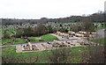
6
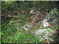
Coppetts Wood Sewage Works
Concrete remains from the sewage works built on this site in the 1870's. The works was closed in 1963 and demolished in 1988. The pile of rubble extends diagonally across the full width of the photo. It might have been a raised walkway over the sewage pans.
Image: © Martin Addison
Taken: 11 Aug 2006
0.10 miles
7
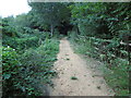
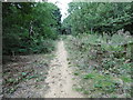
Path in Coppett's Wood
Coppett's Wood was once part of Finchley Common, a large tract of countryside belonging to the Bishop of London. The origin of Coppett's Wood is unclear. It first appeared as woodland on Ordnance Survey maps from surveys of 1862 - 1871, although individual features may date from an earlier time. It is thought to have been used for timber production - the old boundary ditches along the southern and western edges, which survive to this day, may once have served to deter cattle from straying into the wood.
The site was designated as a Local nature Reserve in 1997 and there is free public access.
Image: © Marathon
Taken: 21 Sep 2016
0.11 miles
8
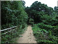
Path in Coppett's Wood
Coppett's Wood was once part of Finchley Common, a large tract of countryside belonging to the Bishop of London. The origin of Coppett's Wood is unclear. It first appeared as woodland on Ordnance Survey maps from surveys of 1862 - 1871, although individual features may date from an earlier time. It is thought to have been used for timber production - the old boundary ditches along the southern and western edges, which survive to this day, may once have served to deter cattle from straying into the wood.
The site was designated as a Local nature Reserve in 1997 and there is free public access.
Image: © Marathon
Taken: 21 Sep 2016
0.12 miles
9
Path in Coppett's Wood
Coppett's Wood was once part of Finchley Common, a large tract of countryside belonging to the Bishop of London. The origin of Coppett's Wood is unclear. It first appeared as woodland on Ordnance Survey maps from surveys of 1862 - 1871, although individual features may date from an earlier time. It is thought to have been used for timber production - the old boundary ditches along the southern and western edges, which survive to this day, may once have served to deter cattle from straying into the wood.
The site was designated as a Local nature Reserve in 1997 and there is free public access.
Image: © Marathon
Taken: 21 Sep 2016
0.12 miles
10
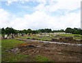
Colney Hatch, cemetery
The northern tip of St Pancras and Islington Cemetery; it looks as if business is booming, and more plots are needed. http://en.wikipedia.org/wiki/St_Pancras_and_Islington_Cemetery
Image: © Mike Faherty
Taken: 4 Aug 2012
0.13 miles