IMAGES TAKEN NEAR TO
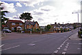
Spencer Road, LONDON, N11 1JX
Introduction
This page details the photographs taken nearby to Spencer Road, N11 1JX by members of the Geograph project.
The Geograph project started in 2005 with the aim of publishing, organising and preserving representative images for every square kilometre of Great Britain, Ireland and the Isle of Man.

There are currently over 7.5m images from over14,400 individuals and you can help contribute to the project by visiting https://www.geograph.org.uk
Image Map
Images are licensed for reuse under creativecommons.org/licenses/by-sa/2.0
Notes
- Clicking on the map will re-center to the selected point.
- The higher the marker number, the further away the image location is from the centre of the postcode.
Image Listing (46 Images Found)
Images are licensed for reuse under creativecommons.org/licenses/by-sa/2.0
Image
Details
Distance
1
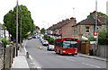
Brunswick Park Road
Looking up the hill towards Betstyle Circle. A 382 bus passes the stop for Marne Avenue on its way to Southgate from Mill Hill East.
Image: © Martin Addison
Taken: 12 May 2012
0.04 miles
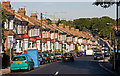
2
Brunswick Park Road, London N11
Looking down Brunswick Park Road in the direction of Betstyle Circus. The junction of Falkland Avenue is on the right and Marshalls Court on the left.
Image: © Christine Matthews
Taken: 9 Apr 2008
0.08 miles
3
Falkland Avenue, London N11
Falkland Avenue as seen from Brunswick Park Road.
Image: © Christine Matthews
Taken: 9 Apr 2008
0.10 miles
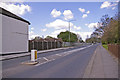
4
Brunswick Park Road
The road descends into a valley that was probably created by a tributary of Pymmes Brook - the stream on the North Middlesex Golf Course seems a likely candidate.
At the bottom it passes New Southgate Recreation Ground before climbing again to a summit beside New Southgate Cemetery, hidden in the trees on the horizon.
Image: © Martin Addison
Taken: 25 Sep 2009
0.10 miles
5
Brunswick Park Road, London N11
Looking down Brunswick Park Road we can see Marshalls Close on the left. Falkland Avenue is on the right.
Image: © Christine Matthews
Taken: 9 Apr 2008
0.11 miles
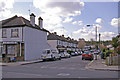
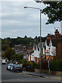
6
Traffic Island, Brunswick Park Road, London N11
The house and garden on the corner of Falkland Avenue is on the left of the image. Looking up the hill towards the recreation ground on the left and the cemetery on the right, which are both in the next gridsquare.
Image: © Christine Matthews
Taken: 9 Apr 2008
0.11 miles
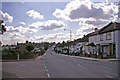
7
Brunswick Park Road, New Southgate
Leading down the hill from Betstyle Circus towards East Barnet. The bus stop is served by route 382 between Southgate Station and Millbrook Park.
Image: © Stephen McKay
Taken: 3 Oct 2017
0.12 miles
10
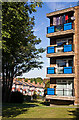
Homestead House and Brunswick Park Road
One of the blocks on a small estate beside Waterfall Road. The houses behind are on Brunswick Park Road.
Image: © Martin Addison
Taken: 25 Sep 2009
0.15 miles