IMAGES TAKEN NEAR TO
Duncan Grove, MILTON KEYNES, MK5 6HL
Introduction
This page details the photographs taken nearby to Duncan Grove, MK5 6HL by members of the Geograph project.
The Geograph project started in 2005 with the aim of publishing, organising and preserving representative images for every square kilometre of Great Britain, Ireland and the Isle of Man.

There are currently over 7.5m images from over14,400 individuals and you can help contribute to the project by visiting https://www.geograph.org.uk
Image Map
Images are licensed for reuse under creativecommons.org/licenses/by-sa/2.0
Notes
- Clicking on the map will re-center to the selected point.
- The higher the marker number, the further away the image location is from the centre of the postcode.
Image Listing (9 Images Found)
Images are licensed for reuse under creativecommons.org/licenses/by-sa/2.0
Image
Details
Distance
1
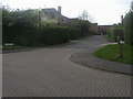
Swan's Way
Swan's Way crosses Vache Lane heading into Oakhill Road
Image: © Shaun Ferguson
Taken: 2 May 2014
0.09 miles
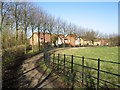
2
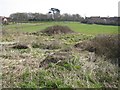
Site for Independent School
Undeveloped site bounded by Portway, Daubeney Gate, Vache Lane and Duncan Grove is shown on Milton Keynes Council's interactive map as "Site for Independent School"
Image: © Malcolm Campbell
Taken: 17 Mar 2009
0.09 miles
3
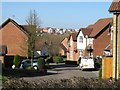
Go West
Looking down Jenkins Close towards newer housing at Grange Farm
Image: © Malcolm Campbell
Taken: 6 Mar 2009
0.11 miles
4
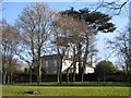
Cedar view
Shenley Park House viewed from Vache Lane
Image: © Malcolm Campbell
Taken: 6 Mar 2009
0.14 miles
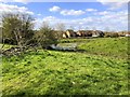
5
Toot edge
A spring view looking towards Jenkins Close before the trees come into leaf.
Image: © Malcolm Campbell
Taken: 6 Mar 2009
0.18 miles
7
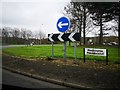
Milton Keynes : Medbourne Roundabout
Looking across the roundabout.
Image: © Lewis Clarke
Taken: 19 Mar 2019
0.21 miles
8
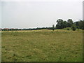
The Toot Motte
"The Toot - it means lookout hill - is a motte-and-bailey fort. It is thought to date from the 12th century, but this is uncertain because of the lack of coins or other finds there." shenleybrookend.net
This is a view of the site remains. To the right of this photo you can see what's left of the lookout hill.
Image: © Mr Biz
Taken: 27 Jul 2006
0.22 miles
9
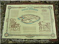
Information Marker
An information plinth just outside of the fenced area of "The Toot", in Shenley Church End.
Image: © Mr Biz
Taken: 27 Jul 2006
0.22 miles