IMAGES TAKEN NEAR TO
Harrowden Lane, BEDFORD, MK44 3EQ
Introduction
This page details the photographs taken nearby to Harrowden Lane, MK44 3EQ by members of the Geograph project.
The Geograph project started in 2005 with the aim of publishing, organising and preserving representative images for every square kilometre of Great Britain, Ireland and the Isle of Man.

There are currently over 7.5m images from over14,400 individuals and you can help contribute to the project by visiting https://www.geograph.org.uk
Image Map
Images are licensed for reuse under creativecommons.org/licenses/by-sa/2.0
Notes
- Clicking on the map will re-center to the selected point.
- The higher the marker number, the further away the image location is from the centre of the postcode.
Image Listing (16 Images Found)
Images are licensed for reuse under creativecommons.org/licenses/by-sa/2.0
Image
Details
Distance
1
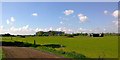
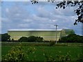
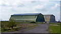
Cardington Hangars 1 and 2
The view South to the massive, brooding airship hangars at Cardington near Bedford. Over 800 feet in length, 180 wide and over 150 high. The hangars built to construct and house Britain's airships of the 1920's and put to a number of uses in more recent years. Hangar 1 (the closest in this photo) is currently undergoing a large renovation project to repair and re-clad.
http://en.wikipedia.org/wiki/RAF_Cardington
Image: © Peter Evans
Taken: 16 May 2013
0.19 miles
2
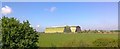
Cardington Hangars 1 and 2
The historic airship hangars at Cardington near Bedford. The massive hangars built to construct and house Britain's airships of the 1920's and put to a number of uses in more recent years. Hangar 1 (the furthest away in this photo) is currently undergoing a large renovation project to repair and re-clad.
http://en.wikipedia.org/wiki/RAF_Cardington
Image: © Peter Evans
Taken: 16 May 2013
0.19 miles
3
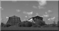
Cardington Hangars 1 and 2
The massive Cardington Airship Hangars 1 and 2 brooding over the neighbouring arable land - 180 feet high and 280 feet wide at their base they dominate the surrounding countryside. Hangar 1 to the right is currently being repaired and re-clad.
http://en.wikipedia.org/wiki/Cardington,_Bedfordshire
Image: © Peter Evans
Taken: 16 May 2013
0.20 miles
4
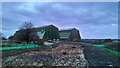
Cardington Airfield Airship Sheds
These sheds are 55m high and about 247m long by 83m across.
Image: © PAUL FARMER
Taken: 8 Nov 2015
0.20 miles
5
Paul Waller Avenue towards the Cardington Hangars
Image: © Philip Jeffrey
Taken: 21 Jan 2014
0.21 miles
6
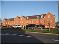
New housing on Carmichael Drive, Shortstown
Image: © David Howard
Taken: 29 Jul 2019
0.21 miles
7
New road and housing in Shortstown
The A600 High Road has been diverted around the original one and has had a new housing estate built alongside it.
Image: © David Howard
Taken: 15 Oct 2017
0.21 miles
8
RAF Cardington, Airship hangars
These were built in the 20's to house airships. Following the disaster with the R101, all work on airships was discontinued.
Image: © Bikeboy
Taken: 30 May 2015
0.22 miles
9
Cardington Airship Hangars
Viewed from the east. See Image for excellent description and links.
The nearer shed is No.2 shed. From 1970 onwards it was leased by the Fire Research Station (based in Borehamwood, Herts) as a large scale test facility, where fires could be lit in relatively still-air conditions. It eventually became part of the Building Research Establishment, which became BRE Ltd. in 1997, when privatised out of the civil service. No.2 hangar is in much better condition than No. 1, as it was completely reclad in the late 1980s.
Description augmented by another member.
Image: © Jonathan Billinger
Taken: 15 Apr 2008
0.23 miles
10
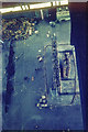
Cardington Airship Hangar No. 2 - Interior photo of E end in 1970
Part of the east end of Hangar No. 2 photographed in 1970. We are looking down from the central roof catwalk 163 feet above the floor of the hangar at an experimental high-rack storage system being subjected to fire tests by the Fire Research Station. (See Image for a more general view of the interior.)
Image: © John Webb
Taken: Unknown
0.24 miles