IMAGES TAKEN NEAR TO
Wolseley Court, BEDFORD, MK42 7AY
Introduction
This page details the photographs taken nearby to Wolseley Court, MK42 7AY by members of the Geograph project.
The Geograph project started in 2005 with the aim of publishing, organising and preserving representative images for every square kilometre of Great Britain, Ireland and the Isle of Man.

There are currently over 7.5m images from over14,400 individuals and you can help contribute to the project by visiting https://www.geograph.org.uk
Image Map
Images are licensed for reuse under creativecommons.org/licenses/by-sa/2.0
Notes
- Clicking on the map will re-center to the selected point.
- The higher the marker number, the further away the image location is from the centre of the postcode.
Image Listing (11 Images Found)
Images are licensed for reuse under creativecommons.org/licenses/by-sa/2.0
Image
Details
Distance
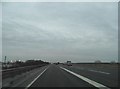
2
A421 bypassing Bedford
Turn off for the A6 and Bedford at the next junction.
Image: © Robin Webster
Taken: 9 Dec 2017
0.15 miles
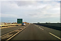
3
Approach to Marsh Leys Junction
This new stretch of the A421 was opened in December 2010. It certainly helps east/west travel in this part of England but there are still bottle necks which can be quite frustrating given the volume of heavy freight traffic which eventually makes its way to Felixstowe.
Image: © Mr Ignavy
Taken: 28 Oct 2011
0.17 miles
5
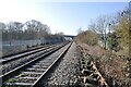
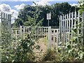
Chantry Estate Foot Crossing
Chantry Estate Foot Crossing - sometimes known as Woburn Road Crossing. A view west towards the A421 bridge. Note the redundant bullhead railway track lying alongside. This has been left here for many years since modern track was installed, and occurs all along the line from Bletchley to Bedford.
Image: © Bob Walters
Taken: 15 Feb 2023
0.18 miles
6
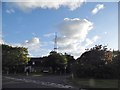
Abbott Crescent at the junction of Woburn Road
The aerial is for the police station below it
Image: © David Howard
Taken: 11 Jun 2017
0.20 miles
7
Woburn Road level crossing
Woburn Road level crossing on the Marston Vale railway line, just south of Woburn Road industrial estate, Kempston, Bedfordshire.
Image: © Sarah Joy
Taken: 5 Jul 2021
0.21 miles
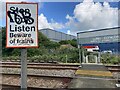
8
Woburn Road level crossing
Woburn Road level crossing on the Marston Vale railway line, just south of Woburn Road industrial estate, Kempston, Bedfordshire.
Image: © Sarah Joy
Taken: 5 Jul 2021
0.21 miles
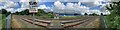
9
Woburn Road level crossing
Woburn Road level crossing on the Marston Vale railway line, just south of Woburn Road industrial estate, Kempston, Bedfordshire.
Image: © Sarah Joy
Taken: 5 Jul 2021
0.21 miles
10

Woburn Road level crossing
Woburn Road level crossing on the Marston Vale railway line, just south of Woburn Road industrial estate, Kempston, Bedfordshire.
Image: © Sarah Joy
Taken: 5 Jul 2021
0.22 miles