IMAGES TAKEN NEAR TO
Lillingstone Dayrell, BUCKINGHAM, MK18 5AX
Introduction
This page details the photographs taken nearby to MK18 5AX by members of the Geograph project.
The Geograph project started in 2005 with the aim of publishing, organising and preserving representative images for every square kilometre of Great Britain, Ireland and the Isle of Man.

There are currently over 7.5m images from over14,400 individuals and you can help contribute to the project by visiting https://www.geograph.org.uk
Image Map
Images are licensed for reuse under creativecommons.org/licenses/by-sa/2.0
Notes
- Clicking on the map will re-center to the selected point.
- The higher the marker number, the further away the image location is from the centre of the postcode.
Image Listing (10 Images Found)
Images are licensed for reuse under creativecommons.org/licenses/by-sa/2.0
Image
Details
Distance
1
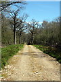
Path through Shirehill Wood
I don't think this path has been used in a very long time. From here you could hear the buzz of cars racing around Silverstone circuit.
Image: © Lisa Jarvis
Taken: 12 Jun 2007
0.06 miles
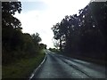
2
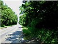
A413 County Border
Here the A413 passes between Shirehill Wood and Lovel Wood. Where the road exits these two woods (which you can just see) is the boundary between Buckinghamshire to the south and Northamptonshire to the north.
Image: © Rob Farrow
Taken: 17 Jun 2006
0.12 miles
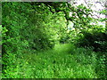
3
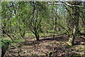
Lovel Wood
Dense undergrowth and trees in Lovel Wood beside the A413 near the Bucks/Northants border.
Image: © Rob Farrow
Taken: 17 Jun 2006
0.12 miles
5
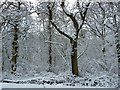
View into snowy Shirehill Wood
A view from the A413 looking into the snow-covered trees of Shirehill Wood to the south of Whittlebury.
Image: © Rob Farrow
Taken: 24 Mar 2013
0.14 miles
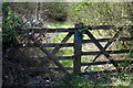
7
Buckinghamshire border
The road from Whittlebury (in Northamptonshire) to Livingstone Lovell (in Buckinghmashire) passes through Shirehill's Wood at the border.
Image: © Lisa Jarvis
Taken: 12 Jun 2007
0.16 miles
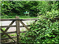
8

A413 through Lovel and Shirehill Woods
The A413 between Whittlebury and the Lillingstones passes through these woods with Lovel Wood on the left and Shirehill Wood on the right. The county boundary between Northamptonshire (to the north) and Buckinghamshire follows the northern edge of these two woods, so this view is just inside the latter county.
Image: © Rob Farrow
Taken: 24 Mar 2013
0.16 miles
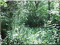
9
In Lovel Wood
The woodland extends on both sides of the A413. Its northern edge is the county boundary between Northamptonshire and Buckinghamshire.
Image: © David Smith
Taken: 17 Oct 2012
0.19 miles