IMAGES TAKEN NEAR TO
Thornborough Road, BUCKINGHAM, MK18 2AH
Introduction
This page details the photographs taken nearby to Thornborough Road, MK18 2AH by members of the Geograph project.
The Geograph project started in 2005 with the aim of publishing, organising and preserving representative images for every square kilometre of Great Britain, Ireland and the Isle of Man.

There are currently over 7.5m images from over14,400 individuals and you can help contribute to the project by visiting https://www.geograph.org.uk
Image Map (Loading...)


Getting Data...Please wait
Leaflet Map data © OpenStreetMap
Images are licensed for reuse under creativecommons.org/licenses/by-sa/2.0
Notes
- Clicking on the map will re-center to the selected point.
- The higher the marker number, the further away the image location is from the centre of the postcode.
Image Listing (15 Images Found)
Images are licensed for reuse under creativecommons.org/licenses/by-sa/2.0
Image
Details
Distance
1
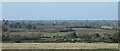
Buckingham church Spire taken from Whaddon Way,Padbury
Image: © susan barnard
Taken: 24 Oct 2008
0.08 miles
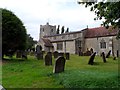
2
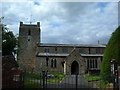
St Mary the Virgin, Padbury
The earliest parts of the church date from around 1210 AD.
Image: © Mr Biz
Taken: 13 Jul 2008
0.09 miles
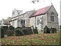
3
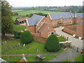
St. Mary's Church Padbury. From the Parapet
Looking South Easterly from the Church parapet.Part of the Churchyard and the recent development
Image: © Tom Dickens
Taken: 3 Oct 2007
0.10 miles
4
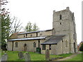
Padbury: The Church of St Mary the Virgin
The nave and chancel date from the 13th century as did the original tower which was however rebuilt in the 17th century. The structure is a Grade II* Listed Building.
The apparent flaw in the photograph is actually an emission from a boiler flue!
This contribution shows how cartographic demands can lead to inaccuracies in mapping. The location of the symbol for the church on the Ordnance Survey 1:50,000 scale mapping plots at least 50 metres away from the actual physical centre of the church on the ground.
Image: © Nigel Cox
Taken: 17 Oct 2010
0.13 miles
5
St Mary the Virgin, Padbury
The nave, chancel and tower are C13,the aisles C14. The tower was rebuilt in C17 and the whole church was restored in 1830 and 1882.
Image: © Bikeboy
Taken: 21 Aug 2014
0.13 miles
6
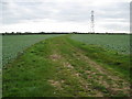
Padbury: Farm track
This track is shown on the Ordnance Survey map of 1880, and seems to have existed only to afford access to the fields from Padbury village.
Image: © Nigel Cox
Taken: 17 Oct 2010
0.13 miles
7
Padbury: The Church of St Mary the Virgin
This is a repeat of Rob's Image from more or less the same angle but on a somewhat gloomier day.
The naming of this church seems to have a curious history. Old Ordnance Survey maps of the Victorian era and up to 1923 call it St Matthew's, yet the 1927 History of the County of Buckingham refers to it as The Church of The Nativity of The Blessed Virgin. By 1977 the Ordnance Survey are calling it St Mary's Church, but by 1983 they had retired from the fray and called it just PW (Place of Worship).
Image: © Nigel Cox
Taken: 17 Oct 2010
0.13 miles
8
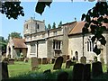
Padbury Church
Tucked away up a little lane (Church Lane unsurprisingly) from the centre of Padbury is this charming little church.
Image: © Rob Farrow
Taken: 17 Jun 2006
0.15 miles
9
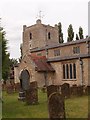
Tower, Church of St Mary the Virgin, Padbury
The squat tower is a typical feature of numerous churches in the villages of Buckinghamshire. A Grade II* listed building, described at this http://list.historicengland.org.uk/resultsingle.aspx?uid=1231852.
Image: © Jim Osley
Taken: 11 Aug 2015
0.15 miles
10
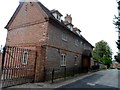
Manor House, Padbury
Built in C18. See http://www.britishlistedbuildings.co.uk/en-407107-manor-house-padbury-buckinghamshire
Image: © Bikeboy
Taken: 21 Aug 2014
0.20 miles