IMAGES TAKEN NEAR TO
Watling Street, MILTON KEYNES, MK17 9NF
Introduction
This page details the photographs taken nearby to Watling Street, MK17 9NF by members of the Geograph project.
The Geograph project started in 2005 with the aim of publishing, organising and preserving representative images for every square kilometre of Great Britain, Ireland and the Isle of Man.

There are currently over 7.5m images from over14,400 individuals and you can help contribute to the project by visiting https://www.geograph.org.uk
Image Map
Images are licensed for reuse under creativecommons.org/licenses/by-sa/2.0
Notes
- Clicking on the map will re-center to the selected point.
- The higher the marker number, the further away the image location is from the centre of the postcode.
Image Listing (15 Images Found)
Images are licensed for reuse under creativecommons.org/licenses/by-sa/2.0
Image
Details
Distance
1
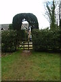
Topiary entrance /exit at Duncombe Wood
This is the wood entrance/exit by Watling Street.
Image: © Michael Trolove
Taken: 22 Jan 2012
0.00 miles
2
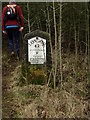
Mile post on the A5
Camera at the ready for this one as it's not far off the edge of a fast stretch of dual carriageway A5. It may also feature an OS Bench Mark, it looks like one to the lower right.
Image: © Michael Trolove
Taken: 22 Jan 2012
0.01 miles
3
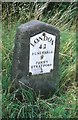
Old Milestone by the A5, south of Little Brickhill
Metal plate attached to stone post by the A5, in parish of Great Brickhill (Aylesbury Vale District), North-bound carriageway, just before slip road to Little Brickhill, on grass verge, 10m South of where crash barrier starts, beside a public footpath that leads to the old road near Wood Lodge, on West side of road. Milton Keynes iron plate, erected by the Holyhead Road (Hockliffe Div) turnpike trust in the 19th century.
Inscription reads:-
LONDON
42
DUNSTABLE
9
FENNY
STRATFORD
2
Carved benchmark on lower front.
Milestone Society National ID: BU_LH42
Image: © A Rosevear
Taken: 19 Jul 2003
0.03 miles
4
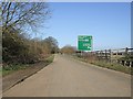
The old A5 (Watling Street)
This is the old A5 that used to carry on through Little Brickhill village. The (comparatively) new A5 now sweeps round the village. The green sign is on this new road, showing how close it is to the old route at this point. I'm classifying this as "Road (disused)" as although still open to traffic, it is no longer the thoroughfare it used to be.
Image: © Rob Farrow
Taken: 14 Mar 2007
0.03 miles
5
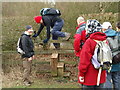
Negotiating a stile with style
Members of the Long Distance Walkers Association waiting their turn to clamber over this stile by the A5.
Image: © Michael Trolove
Taken: 22 Jan 2012
0.04 miles
6
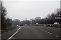
Borough of Milton Keynes : The A5
Heading along the A5.
Image: © Lewis Clarke
Taken: 25 Mar 2018
0.07 miles
7

A5 heading towards Milton Keynes
Here the road deviates right from the Roman Watling Street to bypass Little Brickhill.
Image: © Robin Webster
Taken: 7 Jan 2018
0.07 miles
8
Down the side of the A5
Agricultural land and track near Buttermilk Wood. The A5 is the other side of the hedge.
Image: © Michael Trolove
Taken: 22 Jan 2012
0.10 miles
9
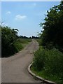
Access to Park Farm
Near to Little Brickhill, just off the old A5 (and the track of the old Roman Road, Watling Street) is this access road to Park Farm.
Image: © Mr Biz
Taken: 8 Jun 2008
0.13 miles
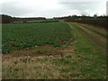
10
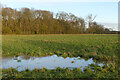
Farmland, Little Brickhill
Viewed from a footpath to the east of the A5.
Image: © Andrew Smith
Taken: 30 Mar 2024
0.14 miles