IMAGES TAKEN NEAR TO
Primrose Lane, SITTINGBOURNE, ME9 8EB
Introduction
This page details the photographs taken nearby to Primrose Lane, ME9 8EB by members of the Geograph project.
The Geograph project started in 2005 with the aim of publishing, organising and preserving representative images for every square kilometre of Great Britain, Ireland and the Isle of Man.

There are currently over 7.5m images from over14,400 individuals and you can help contribute to the project by visiting https://www.geograph.org.uk
Image Map
Images are licensed for reuse under creativecommons.org/licenses/by-sa/2.0
Notes
- Clicking on the map will re-center to the selected point.
- The higher the marker number, the further away the image location is from the centre of the postcode.
Image Listing (20 Images Found)
Images are licensed for reuse under creativecommons.org/licenses/by-sa/2.0
Image
Details
Distance
1
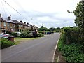
Gordon Cottages, Tunstall Road, Bredgar
Image: © Chris Whippet
Taken: 29 Jun 2016
0.05 miles
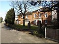
2
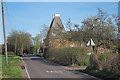
The Oast House, Bredgar Road, Tunstall, Kent
Image: © Oast House Archive
Taken: 6 Apr 2011
0.12 miles
3
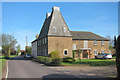
The Oast House, Bredgar Road, Tunstall, Kent
Image: © Oast House Archive
Taken: 6 Apr 2011
0.12 miles
4
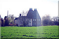
The Oast House, Bredgar Road, Tunstall, Kent
Image: © Oast House Archive
Taken: 6 Apr 2011
0.12 miles
5
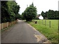
Rookery Close, Bredgar
Formerly part of Primrose Lane before the construction of the M2 Motorway in the early 1960s.
Image: © Chris Whippet
Taken: 29 Jun 2016
0.14 miles
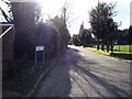
6
The White House, Bredgar
Before the M2 motorway was built in the 1960s this fine house stood on the main road north out of the village, it is now in the cul-de-sac, Rookery Close as the road was diverted over the new bridge across the motorway cutting. The house used to be white but the facade is now plain red brick.
Image: © Penny Mayes
Taken: 1 Mar 2006
0.15 miles
7
Rookery Close, Bredgar
Once the main road into Bredgar village from the north but now a cul-de-sac. Beyond the hedge at the end, in a cutting, is the M2 motorway. See http://www.geograph.org.uk/photo/133522 and http://www.geograph.org.uk/photo/133448
Image: © Penny Mayes
Taken: 1 Mar 2006
0.15 miles
8
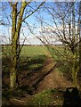
Footpath to Hearts Delight Road
Running north from Tunstall Road, Bredgar, the shortest and safest route to Sittingbourne on foot, it comes out by Image (but no chance of cadging a lift this way).
Image: © Penny Mayes
Taken: 1 Mar 2006
0.16 miles
9

Eastbound M2
Between junctions 5 and 6.
Image: © Robin Webster
Taken: 2 Jul 2018
0.17 miles
10
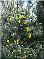
Gorse in flower
Just north of the bridge over the M2, Tunstall Road, Bredgar.
Image: © Penny Mayes
Taken: 1 Mar 2006
0.19 miles