IMAGES TAKEN NEAR TO
Lynsted Lane, SITTINGBOURNE, ME9 0EN
Introduction
This page details the photographs taken nearby to Lynsted Lane, ME9 0EN by members of the Geograph project.
The Geograph project started in 2005 with the aim of publishing, organising and preserving representative images for every square kilometre of Great Britain, Ireland and the Isle of Man.

There are currently over 7.5m images from over14,400 individuals and you can help contribute to the project by visiting https://www.geograph.org.uk
Image Map
Images are licensed for reuse under creativecommons.org/licenses/by-sa/2.0
Notes
- Clicking on the map will re-center to the selected point.
- The higher the marker number, the further away the image location is from the centre of the postcode.
Image Listing (27 Images Found)
Images are licensed for reuse under creativecommons.org/licenses/by-sa/2.0
Image
Details
Distance
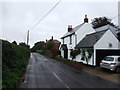
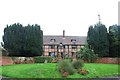
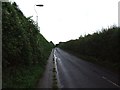
2
Lynsted Lane
Pond Cottage is the white building on the right.
Image: © pam fray
Taken: 16 Jan 2017
0.02 miles
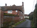
3
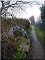
Footpath off Lynsted Lane
Leading to Mill Lane and Sunderland Farm.
Image: © pam fray
Taken: 16 Jan 2017
0.03 miles
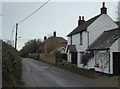
4
Bogle, Lynsted Lane
Bogle Road is on the left. Bogle is a Grade II* listed building dating from the 16th century and extended in the 17th and 20th centuries.
Image: © pam fray
Taken: 16 Jan 2017
0.04 miles
5
Bogle, near Lynsted
http://www.britishlistedbuildings.co.uk/en-176283-bogle-with-garden-wall-lynsted-with-king
Image: © Chris Whippet
Taken: 13 Oct 2013
0.04 miles
6
Bogle Road, approaching Lynsted Lane
The boundary wall of Bogle is on the left.
Image: © pam fray
Taken: 16 Jan 2017
0.05 miles
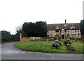
7
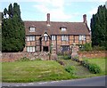
Bogle
Bogle is the name on the map but I have seen this Tudor/Jacobean house called "Beaugill" in an account published in 1926. The board on the gable above the porch reads "1643 H.W.I.I.", the letters apparently standing for Hugessen (the family name), William, John and James. The house dates from earlier but was purchased by the Hugessens in 1643 and enlarged by them. The house stands at the junction of Lynsted Lane with Bogle Road.
Image: © Penny Mayes
Taken: 28 May 2005
0.06 miles
8
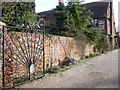
Gate to Bogle from Lynsted Lane
One of the "peacock" gates at the entrance to Bogle on the corner of Lynsted Lane and Bogle Road.
Image: © pam fray
Taken: 3 Feb 2008
0.10 miles
10

Rape coming into bloom
View from Bogle Road.
Image: © pam fray
Taken: 17 Mar 2008
0.15 miles