IMAGES TAKEN NEAR TO
Ocean Drive, GILLINGHAM, ME7 1GS
Introduction
This page details the photographs taken nearby to Ocean Drive, ME7 1GS by members of the Geograph project.
The Geograph project started in 2005 with the aim of publishing, organising and preserving representative images for every square kilometre of Great Britain, Ireland and the Isle of Man.

There are currently over 7.5m images from over14,400 individuals and you can help contribute to the project by visiting https://www.geograph.org.uk
Image Map
Images are licensed for reuse under creativecommons.org/licenses/by-sa/2.0
Notes
- Clicking on the map will re-center to the selected point.
- The higher the marker number, the further away the image location is from the centre of the postcode.
Image Listing (140 Images Found)
Images are licensed for reuse under creativecommons.org/licenses/by-sa/2.0
Image
Details
Distance
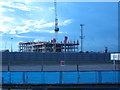
1
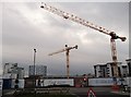
Cranes at Victory Pier Development
More construction is going on at the large development site beside Pier Road.
In the background is the Gasometer, near Gillingham Strand and on the right, the student apartments Liberty Quays.
Image: © David Anstiss
Taken: 14 Dec 2011
0.02 miles
2
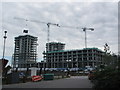
More blocks apartments at Victory Pier
As seen from Gillingham Pier
Image: © David Anstiss
Taken: 28 Aug 2015
0.02 miles
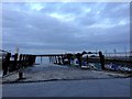
3
Another development in Victory Pier
Another large housing block in the development site.
Was later named Marina Heights.
See Image, when complete.
Image: © David Anstiss
Taken: 14 Sep 2011
0.03 miles
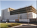
4
South Shore, Victory Pier
Block M of the large development area. This block is a shared ownership scheme block of apartments.
As seen from Ocean Drive.
Image: © David Anstiss
Taken: 19 Mar 2012
0.03 miles
5
Victory Pier Development
The large hotel complex being built on Gillingham coast by Berkeley Homes.
More developments around the hotel are planned.
See http://www.christiecorporate.com/ccc/pdf/GillinghamRiverside.pdf for a 'vision of the future'.
Image: © David Anstiss
Taken: 13 Aug 2010
0.03 miles
6
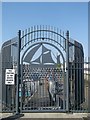
Gate to Gillingham Pier
Has a cut metal image of a Thames wharf barge.
Image: © David Anstiss
Taken: 6 Jun 2013
0.04 miles
7

The Boathouse, Victory Pier
This large block of apartments is one of the early phases of the Victory Pier Development being built by the Berkeley Group.
On the ground floor, on the left is a fitness studio and on the right, tenants are being sort for a bar/diner facility.
In the foreground is Image
See http://www.lv21.co.uk/lv21-blog/
Image: © David Anstiss
Taken: 19 Mar 2012
0.04 miles
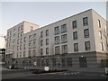
8
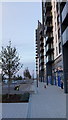
Pavement alongside Pier Approach Road
One of the new apartment buildings of Victory Pier called Peninsula Quay.
Gillingham Pier is just seen on the left.
Image: © David Anstiss
Taken: 28 Sep 2017
0.04 miles
10
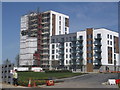
More development at Liberty Quays, Chatham
As seen from Ocean Drive.
Housing blocks are being built in the large development site beside the River Medway.
Block B is the large tower block and Block D is the other block.
Image: © David Anstiss
Taken: 1 May 2013
0.05 miles