IMAGES TAKEN NEAR TO
Coombe Close, SNODLAND, ME6 5EF
Introduction
This page details the photographs taken nearby to Coombe Close, ME6 5EF by members of the Geograph project.
The Geograph project started in 2005 with the aim of publishing, organising and preserving representative images for every square kilometre of Great Britain, Ireland and the Isle of Man.

There are currently over 7.5m images from over14,400 individuals and you can help contribute to the project by visiting https://www.geograph.org.uk
Image Map
Images are licensed for reuse under creativecommons.org/licenses/by-sa/2.0
Notes
- Clicking on the map will re-center to the selected point.
- The higher the marker number, the further away the image location is from the centre of the postcode.
Image Listing (28 Images Found)
Images are licensed for reuse under creativecommons.org/licenses/by-sa/2.0
Image
Details
Distance
2
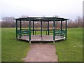
Bandstand within Ham Hill Park
On footpath from Saltings Road, to Sampson Road or to footbridge over A228 Snodland By-Pass.
Image: © David Anstiss
Taken: 12 Dec 2008
0.09 miles
8
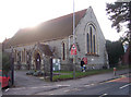
All Saints Snodland with Christ Church Lower Birling
This small church stands on the Malling Road, at the southern end of the "old" part of Snodland.
I am grateful to the current rector of the church who contacted me with the following information regarding the name of the church: Christ Church is in the town of Snodland, but its official ecclesiastical title is Christ Church, Lower Birling. It needs to be distinguished from a different (much older) church called All Saints, Snodland. Originally the churches were located in two separate parishes of Snodland and Lower Birling.
Image: © Richard Dorrell
Taken: 22 Jan 2008
0.15 miles
9
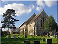
All Saints' Snodland with Christ Church Lower Birling
Seen from the east. The curious name of the church is explained in Richard Dorrell's contribution: Image
Image: © Stefan Czapski
Taken: 15 Mar 2017
0.15 miles