IMAGES TAKEN NEAR TO
Park End View, Kingsmead Park, ROCHESTER, ME3 9TR
Introduction
This page details the photographs taken nearby to Park End View, Kingsmead Park, ME3 9TR by members of the Geograph project.
The Geograph project started in 2005 with the aim of publishing, organising and preserving representative images for every square kilometre of Great Britain, Ireland and the Isle of Man.

There are currently over 7.5m images from over14,400 individuals and you can help contribute to the project by visiting https://www.geograph.org.uk
Image Map
Images are licensed for reuse under creativecommons.org/licenses/by-sa/2.0
Notes
- Clicking on the map will re-center to the selected point.
- The higher the marker number, the further away the image location is from the centre of the postcode.
Image Listing (29 Images Found)
Images are licensed for reuse under creativecommons.org/licenses/by-sa/2.0
Image
Details
Distance
1
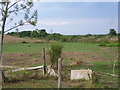
Kingsmead Park caravan park, Allhallows-on-Sea
A path at the southern end of Kingsmead Park caravan park, in Allhallows-on-Sea.
Image: © Malc McDonald
Taken: 23 Feb 2019
0.01 miles
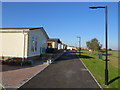
2
Path through Kingsmead Park caravan park, Allhallows-on-Sea
A path through Kingsmead park caravan park in Allhallows-on-Sea, in Kent.
Image: © Malc McDonald
Taken: 23 Feb 2019
0.04 miles
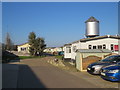
3
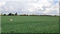
View from Binney Road
This is the view from Binney Road which leads from Allhallows to Binney Farm and Allhallows Marshes. There are a number of horse paddocks in this immediate area.
On either side of the corrugated iron shelter for horses can be seen the embankment of the former branch railway line from Stoke Junction to Allhallows-on-Sea station. The latter was roughly where the buildings in the distance can be seen. The railway was a very short-lived affair. It was opened on 16th May 1932 by the Southern Railway in an effort to develop a seaside resort at Allhallows on Sea. A station hotel was built but the rather bleak location could never compete with other resorts and although the branch was doubled in 1935, it always struggled. After the Second World War there was a steady decline in passengers and the line was singled again in 1957. It finally closed on 4th December 1961. See http://www.disused-stations.org.uk/a/allhallows_on_sea/ for a fuller history of the branch.
Image: © Marathon
Taken: 26 Jul 2014
0.08 miles
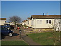
4
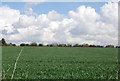
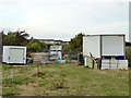
Kingsmead Park caravan park, Allhallows-on-Sea
A driveway through Kingsmead Park caravan park in Allhallows-on-Sea, in Kent.
The silver-coloured water tower is a surviving relic of a railway station which previously occupied this site. The station opened in 1932 but was closed less than 30 years later. A more detailed history of the railway station can be found on the Disused Stations website: http://www.disused-stations.org.uk/a/allhallows_on_sea/
Image: © Malc McDonald
Taken: 23 Feb 2019
0.14 miles
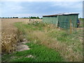
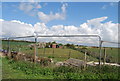
6
A former horse buried near a former railway
The horse called Chilly Bridge died in 1998 and the railway, the former embankment of which is seen beyond, closed in 1961 after less than 30 years. For more information on both and a slightly different view go to http://www.geograph.org.uk/photo/4090989
Image: © Marathon
Taken: 26 Jul 2014
0.15 miles
7

A dead horse and a dead railway
This is the view from Binney Road which leads from Allhallows to Binney Farm and Allhallows Marshes. There are a number of horse paddocks in this immediate area. One of the horses was buried here. The inscription says "CHILLY BRIDGE C.B. 1.11.73 - 24.10.98" and the lying horse in stone is next to it.
The embankment behind is the remains of the former branch railway line from Stoke Junction to Allhallows-on-Sea station. The railway was a very short-lived affair. It was opened on 16th May 1932 by the Southern Railway in an effort to develop a seaside resort at Allhallows on Sea. A station hotel was built but the rather bleak location could never compete with other resorts and although the branch was doubled in 1935, it always struggled. After the Second World War there was a steady decline in passengers and the line was singled again in 1957. It finally closed on 4th December 1961. See http://www.disused-stations.org.uk/a/allhallows_on_sea/ for a fuller history of the branch.
Image: © Marathon
Taken: 26 Jul 2014
0.15 miles
8
The old railway line
The remains of the branch line from Stoke Junction to Allhallows.
Image: © N Chadwick
Taken: 21 Apr 2012
0.16 miles
10
Track of old railway, Allhallows
Looking from the site of the Binney Road level crossing towards the terminus of the branch which only existed from 1932 to 1961. The houses are built on the track bed just before the line fanned for the terminus and its sidings.
Image: © Robin Webster
Taken: 15 Oct 2016
0.16 miles