IMAGES TAKEN NEAR TO
Windermere, FAVERSHAM, ME13 8JG
Introduction
This page details the photographs taken nearby to Windermere, ME13 8JG by members of the Geograph project.
The Geograph project started in 2005 with the aim of publishing, organising and preserving representative images for every square kilometre of Great Britain, Ireland and the Isle of Man.

There are currently over 7.5m images from over14,400 individuals and you can help contribute to the project by visiting https://www.geograph.org.uk
Image Map
Images are licensed for reuse under creativecommons.org/licenses/by-sa/2.0
Notes
- Clicking on the map will re-center to the selected point.
- The higher the marker number, the further away the image location is from the centre of the postcode.
Image Listing (107 Images Found)
Images are licensed for reuse under creativecommons.org/licenses/by-sa/2.0
Image
Details
Distance
1
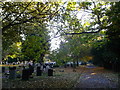
Path in Faversham Cemetery
This long path is an access road within the cemetery beside Love Lane.
The conifers on the right are beside the Windermere road housing estate.
Image: © David Anstiss
Taken: 27 Oct 2012
0.02 miles
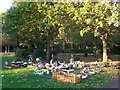
2

War graves in Faversham Cemetery
Burial ground of the armed forces who died in World War II.
Image: © pam fray
Taken: 3 May 2020
0.06 miles
3
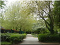
Path in Faversham Cemetery
This is the garden area to the south west of the main burial ground.
Image: © pam fray
Taken: 3 May 2020
0.08 miles

6
Path in Faversham Cemetery (2)
This long path is an access road within the cemetery beside Love Lane, it leads through the cemetery.
Image: © David Anstiss
Taken: 27 Oct 2012
0.10 miles
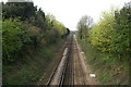
7
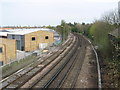
Railway to Whitstable, from Faversham
As seen from long footbridge near Recreation Ground.
Image: © David Anstiss
Taken: 10 Apr 2009
0.10 miles
8
Children's section, Faversham Cemetery
This area of the large cemetery beside Love Lane is devoted to children.
Image: © David Anstiss
Taken: 27 Oct 2012
0.10 miles
9
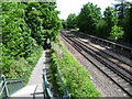
The line to Canterbury East
This view is from towards the southern end of the long footbridge over the railway lines between Faversham Recreation Ground and Preston Avenue. At first it passes over the line from Faversham to Whitstable and then the line from Faversham to Selling, Canterbury East and Dover Priory. This is the latter looking towards Selling. The line from Faversham to Canterbury East was opened on 9th July 1860 by the London, Chatham & Dover Railway.
Image: © Marathon
Taken: 28 May 2015
0.11 miles
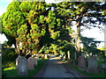
10
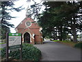
The chapel at the entrance to Faversham cemetery
Viewed from the gateway in Love Lane. The chapel was designed by Edwin Pover and the cemetery opened on 17 May 1898.
Image: © pam fray
Taken: 21 Dec 2008
0.11 miles