IMAGES TAKEN NEAR TO
Grove Place, FAVERSHAM, ME13 7FH
Introduction
This page details the photographs taken nearby to Grove Place, ME13 7FH by members of the Geograph project.
The Geograph project started in 2005 with the aim of publishing, organising and preserving representative images for every square kilometre of Great Britain, Ireland and the Isle of Man.

There are currently over 7.5m images from over14,400 individuals and you can help contribute to the project by visiting https://www.geograph.org.uk
Image Map
Images are licensed for reuse under creativecommons.org/licenses/by-sa/2.0
Notes
- Clicking on the map will re-center to the selected point.
- The higher the marker number, the further away the image location is from the centre of the postcode.
Image Listing (108 Images Found)
Images are licensed for reuse under creativecommons.org/licenses/by-sa/2.0
Image
Details
Distance
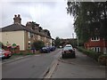
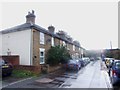
2
![Ospringe houses [12]](https://s3.geograph.org.uk/geophotos/07/05/77/7057719_4e5f3e9d_120x120.jpg)
Ospringe houses [12]
Numbers 20 and 22 Ospringe Street are a pair of 17th century houses constructed of painted brick under a tile roof. There is an early 19th century extension on the right with a modern shopfront. Listed, grade II, with details at: https://historicengland.org.uk/listing/the-list/list-entry/1069435
Ospringe is a village and area of Faversham, Kent. The village lies on the Roman road Watling Street (now the A2). The historic Maison Dieu fronts onto Watling Street and the remains of substantial Roman buildings, thought to be the site of the Durolevum mentioned in the Antonine Itinerary, have been found nearby.
Image: © Michael Dibb
Taken: 5 Sep 2021
0.01 miles
3
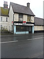
A J Barkaway, 20, Ospringe Street (A2)
This is a grade II, former butcher’s shop, which is included in the planning permission, which was granted by Swale Borough Council under application number 16/505706/FULL for the “demolition of outbuildings and erection of 6 new dwellings and conversion of existing stable building/cold store into a residential dwelling, as amended by drawings received 1 November 2016”.
Image: © John Baker
Taken: 3 Dec 2017
0.02 miles
4
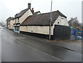
Former butcher?s shop & stable building/cold store, Ospringe Street (A2)
The grade II former butcher’s shop was the premises of A J Barkaway and both it and the stable building/cold store are included in the planning permission, which was granted by Swale Borough Council under application number 16/505706/FULL for the “demolition of outbuildings and erection of 6 new dwellings and conversion of existing stable building/cold store into a residential dwelling, as amended by drawings received 1 November 2016”.
To the right of the buildings is a Image, which is included in the planning permission.
Image: © John Baker
Taken: 3 Dec 2017
0.02 miles
5
22, Ospringe Street
The house is attached to Image, a grade II, former butcher’s shop, which is included in the planning permission, which was granted by Swale Borough Council under application number 16/505706/FULL for the “demolition of outbuildings and erection of 6 new dwellings and conversion of existing stable building/cold store into a residential dwelling, as amended by drawings received 1 November 2016”.
Image: © John Baker
Taken: 18 Nov 2018
0.02 miles
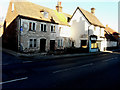
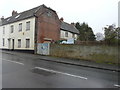
8
![Ospringe houses [13]](https://s0.geograph.org.uk/geophotos/07/05/77/7057720_7e3f1924_120x120.jpg)
Ospringe houses [13]
Now a private dwelling, number 33 Ospringe Street is the former Anchor Inn which closed circa 2000. Constructed in the early 19th century of pebbledashed brick under a tile roof. Listed, grade II, with details at: https://historicengland.org.uk/listing/the-list/list-entry/1343868
Ospringe is a village and area of Faversham, Kent. The village lies on the Roman road Watling Street (now the A2). The historic Maison Dieu fronts onto Watling Street and the remains of substantial Roman buildings, thought to be the site of the Durolevum mentioned in the Antonine Itinerary, have been found nearby.
Image: © Michael Dibb
Taken: 5 Sep 2021
0.02 miles
9
30, Ospringe Street (A2)
A board, in the garden of what appears to be a derelict house, reads “development opportunity, conversion and new construction providing 11 apartments, subject to the normal consents”.
Image: © John Baker
Taken: 3 Dec 2017
0.02 miles
10
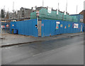
Building site, Ospringe Street
Planning permission was granted by Swale Borough Council under application number 16/505706/FULL for the “demolition of outbuildings and erection of 6 new dwellings and conversion of existing stable building/cold store into a residential dwelling, as amended by drawings received 1 November 2016”.
This image shows a Image, both of which are included in the planning permission.
Image: © John Baker
Taken: 3 Dec 2017
0.03 miles