IMAGES TAKEN NEAR TO
Holbeam Road, FAVERSHAM, ME13 0HS
Introduction
This page details the photographs taken nearby to Holbeam Road, ME13 0HS by members of the Geograph project.
The Geograph project started in 2005 with the aim of publishing, organising and preserving representative images for every square kilometre of Great Britain, Ireland and the Isle of Man.

There are currently over 7.5m images from over14,400 individuals and you can help contribute to the project by visiting https://www.geograph.org.uk
Image Map
Images are licensed for reuse under creativecommons.org/licenses/by-sa/2.0
Notes
- Clicking on the map will re-center to the selected point.
- The higher the marker number, the further away the image location is from the centre of the postcode.
Image Listing (11 Images Found)
Images are licensed for reuse under creativecommons.org/licenses/by-sa/2.0
Image
Details
Distance
1
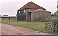
Holbeam Farm entrance, Stalisfield ? converted to ?modern country living?
From the 17th century, when my family of North Downs farmers had the lease of Holbeam Farm for some 60 years, the farm was owned by St Bartholomew’s Hospital in London – the doctors may still own it today. Judging by its surviving buildings, it was a substantial farm property. It had the advantage of fairly level ground for cultivation, not usual up on this part of the Downs (at 450 feet ASL), where farmers also have to contend with heavy clay soil laced with stones and stronger winds, severer weather and a shorter growing season than below in the valley. Thus in 1839 the Hospital owners rebuilt part of it and developed it as a model upland farm. Today, however, its grand old flint-walled buildings have been converted to modern draught-free ‘country living’. It has a neat but desolate air - sans crops, sans animals, sans mud, sans everything. But see the view Image
See also the Gallery at: http://www.geograph.org.uk/gallery/trail_of_a_kentish_farming_family_9094 (background family story http://books.google.com/books?id=hrpS_YQ9FoAC&printsec=frontcover&dq=On+Kentish+Chalk )
Image: © D Gore
Taken: Unknown
0.04 miles
2
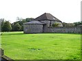
Holbeam threshing house
Flint wheel house and threshing house, now converted to living accommodation.
Image: © Penny Mayes
Taken: 21 Oct 2006
0.05 miles
4
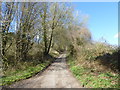
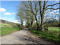
Looking up Holbeam Road
This is a fairly remote crossroads with Holbeam Road ahead, Church Road to the left and right, and Pettfield Hill Road behind. Holbeam Road passes through woodland ahead with Holbeam Wood to the left of the road and Sprats Wood to the right. See also http://www.geograph.org.uk/photo/5320895
Image: © Marathon
Taken: 21 Mar 2017
0.16 miles
5
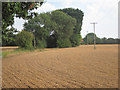
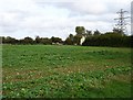
Field east of Stalisfield Road
Growing what looks like kale.
Image: © Robin Webster
Taken: 8 Oct 2015
0.18 miles
6
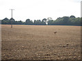
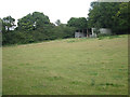
Field by Holbeam Road
A hare runs across the field.
Image: © Oast House Archive
Taken: 19 Aug 2011
0.21 miles
7
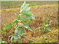
Regrowth of beans and rape
In the stubble field seen here Image
Image: © Penny Mayes
Taken: 21 Oct 2006
0.22 miles
8
Church Road
The church in the road name is Stalisfield which is actually in the other direction as shown by the signpost. Faversham is marked as 5 miles in this direction. This is a fairly remote crossroads with Church Road ahead and behind, Holbeam Road to the left and Pettfield Hill Road to the right. The other three roads pass fairly quickly into woodland but Church Road ahead passes along the bottom of an open valley until it reaches Hockley.
Image: © Marathon
Taken: 21 Mar 2017
0.22 miles
9
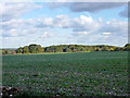
New rape crop
Near the junction of Holbeam Road with Stalisfield Road.
Image: © Penny Mayes
Taken: 21 Oct 2006
0.23 miles
10
Implement shed off Church Road
Holbeam to the right.
Image: © Oast House Archive
Taken: 19 Aug 2011
0.23 miles