IMAGES TAKEN NEAR TO
ME12 3XH
Introduction
This page details the photographs taken nearby to ME12 3XH by members of the Geograph project.
The Geograph project started in 2005 with the aim of publishing, organising and preserving representative images for every square kilometre of Great Britain, Ireland and the Isle of Man.

There are currently over 7.5m images from over14,400 individuals and you can help contribute to the project by visiting https://www.geograph.org.uk
Image Map
Images are licensed for reuse under creativecommons.org/licenses/by-sa/2.0
Notes
- Clicking on the map will re-center to the selected point.
- The higher the marker number, the further away the image location is from the centre of the postcode.
Image Listing (15 Images Found)
Images are licensed for reuse under creativecommons.org/licenses/by-sa/2.0
Image
Details
Distance
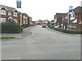
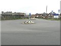
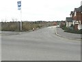
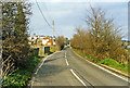
2
Shurland Place
Is the name of this estate whose blue nameplate can be seen on the right. At this point along Scocles Road, a roundabout has been created to take traffic into the estate along Thistle Hill Way (seen here, straight ahead).
Image: © John Baker
Taken: 22 Aug 2012
0.08 miles
3
A new look for the entrance to Shurland Place
Seen from Scocles Road, the new houses under construction have hidden part of the view I photographed last year Image
Image: © John Baker
Taken: 29 Sep 2013
0.09 miles
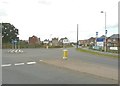
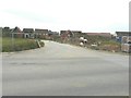
4
Scocles Road
Taken from near its junction with Elm Lane (seen here entering from the right) with the pointed roof of the tower of Minster Abbey on the horizon.
Image: © John Baker
Taken: 22 Aug 2012
0.09 miles
5
Crocus Avenue, Shurland Place
There is only a name-plate on the right, so far.
Image: © John Baker
Taken: 29 Sep 2013
0.10 miles
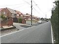
6
Honeysuckle Drive, Shurland Place
Some houses are still to be built along it.
Image: © John Baker
Taken: 29 Sep 2013
0.11 miles
7
102-118, Scocles Road
Number 118 is the house nearest to the camera. A similar view last year showed Image
Image: © John Baker
Taken: 29 Sep 2013
0.14 miles
8
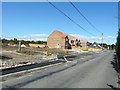
New houses under construction in Scocles Road
Some houses have been completed, others have only got as far as the foundations (at this end of the building plot). Note the parking space that has been provided beside the road.
Image: © John Baker
Taken: 29 Sep 2012
0.14 miles

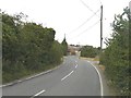
10
Site of former Minster-on-Sea station, 1995
View NNE on Scocles Road, towards Minster-on-Sea: ex-SE&CR Sheppey (Queenborough - Leysdown) Light Railway, all closed 4/12/50.
Image: © Ben Brooksbank
Taken: 11 Mar 1995
0.18 miles