IMAGES TAKEN NEAR TO
Abbey Close, SHEERNESS, ME12 3SZ
Introduction
This page details the photographs taken nearby to Abbey Close, ME12 3SZ by members of the Geograph project.
The Geograph project started in 2005 with the aim of publishing, organising and preserving representative images for every square kilometre of Great Britain, Ireland and the Isle of Man.

There are currently over 7.5m images from over14,400 individuals and you can help contribute to the project by visiting https://www.geograph.org.uk
Image Map
Images are licensed for reuse under creativecommons.org/licenses/by-sa/2.0
Notes
- Clicking on the map will re-center to the selected point.
- The higher the marker number, the further away the image location is from the centre of the postcode.
Image Listing (131 Images Found)
Images are licensed for reuse under creativecommons.org/licenses/by-sa/2.0
Image
Details
Distance
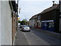
1
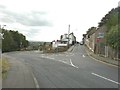
The centre of Minster
Straight ahead is the High Street, a one-way road, while descending to the left is Back Lane
Image: © John Baker
Taken: 22 Aug 2012
0.03 miles
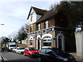
2
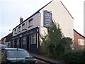
The Highlander Pub, Minster
On 13 High Street.
Image: © David Anstiss
Taken: 24 Jan 2009
0.04 miles
4
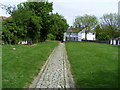
Pathway leading to Chapel Street Minster
The pathway leads from Minster Abbey through the remembrance gardens to Chapel Street
Image: © PAUL FARMER
Taken: 3 May 2009
0.05 miles
7
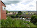
View south from Minster High Street
Minster Abbey is named after a Saxon nunnery here which was founded in 664AD and sacked by the Danes in 835. This was re-established about 1130, when the present church was built, incorporating and still showing parts of its Saxon predecessor. It is located on the highest point of the Isle of Sheppey and gives superb views to the south across the island and beyond The Swale to the mainland. A full description of the Abbey can be found at http://www.minsterabbey.org.uk/3.html
This view is from High Street, just to the south of the churchyard. The hills on the horizon are on the mainland.
Image: © Marathon
Taken: 3 Jul 2016
0.06 miles
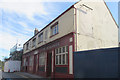
9
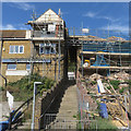
Stairway access from Back Lane to High Street, Minster
A careful study of the map shows if you continue across the High Street you reach the entrance to the magnificent Minster Abbey - 'Stairway to Heaven' perhaps?
Image: © Richard Rogerson
Taken: 17 Sep 2019
0.06 miles
10

Minster Abbey: inscription on the headstone of a dockyard quartermaster, 1821
The inscription is quite finely lettered, but the stone seems to have suffered from rough handling - as well as weathering on this hilltop close to the sea.
My 21st-century keyboard won't allow me to transcribe all the flourishes of the Georgian inscription, but the stone commemorates:
JAMES MART
Late Quartermaster in H.M.
Dock Yard Sheerness
Who departed this Life
Anno 1821 Feby. 14th. Aged 78
There are then three lines of verse, partly obscured by lichen. What's more, it looks as if the mason wasn't sure of his spelling and tried to re-work some of the letters. I won't guess at the third line, but the first two lines seem to read:
To p(atient?) Faith the prize is shure
And . . . . to the end endure
Image shows a very similar stone - the material is the same and the inscription could well be the work of the same man.
Image: © Stefan Czapski
Taken: 29 Jul 2017
0.06 miles