IMAGES TAKEN NEAR TO
Artillery Road, SHEERNESS, ME12 1BU
Introduction
This page details the photographs taken nearby to Artillery Road, ME12 1BU by members of the Geograph project.
The Geograph project started in 2005 with the aim of publishing, organising and preserving representative images for every square kilometre of Great Britain, Ireland and the Isle of Man.

There are currently over 7.5m images from over14,400 individuals and you can help contribute to the project by visiting https://www.geograph.org.uk
Image Map
Images are licensed for reuse under creativecommons.org/licenses/by-sa/2.0
Notes
- Clicking on the map will re-center to the selected point.
- The higher the marker number, the further away the image location is from the centre of the postcode.
Image Listing (124 Images Found)
Images are licensed for reuse under creativecommons.org/licenses/by-sa/2.0
Image
Details
Distance
1

King William Lion Monument, Sheerness Dockyard
The rampant lion dates from the 17th century and was removed from the main gate of the 1st Garrison Fort. It is Grade II listed. In the background is the former Captain Superintendent's House.
Image: © pam fray
Taken: 14 Oct 2017
0.03 miles
3
North and South Gatehouses, Sheerness Dockyard
Built 1820 for the naval dockyard here. Grade II listed buildings. Now offices.
Image: © Robin Webster
Taken: 16 May 2018
0.03 miles
6
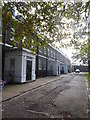
Dockyard Terrace, Sheerness
A row of Georgian properties, some still undergoing restoration, to the south of Church Road and west of the former Royal Dockyard Church.
Image: © pam fray
Taken: 14 Oct 2017
0.06 miles
7
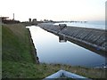
Moat at Sheerness Dockyard
Between the sea wall and the eastern end of the dockyard. Part of the sea and naval defences, the housing half way along the sea wall is a pump. For details of the buildings left of centre in the picture, see Image
Image: © Penny Mayes
Taken: 21 Jan 2006
0.06 miles
8

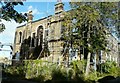
Former Royal Dockyard Church, Sheerness Dockyard
Viewed from the western end of Church Road. The church was built in 1828 and was severely damaged by fire in the 19th century. Empty since 1970, it was gutted by another fire in 2001. It is Grade II* listed and is undergoing restoration but as a community building rather than a church as it is deconsecrated.
Image: © pam fray
Taken: 14 Oct 2017
0.06 miles
9
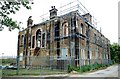
Sheerness Dockyard Church - from the back
According to http://www.geocaching.com/seek/cache_details.aspx?guid=2b120432-1517-47c7-8aeb-9d8101c042af Sheerness Dockyard Church was reduced to a shell after a fire in 2001. I visited the church, especially, in the hope of seeing restoration in progress but none was being carried out.
Image: © John Baker
Taken: 29 Sep 2012
0.07 miles
10
The Shell of the Garrison Church (Rear) Blue Town Sheerness
Image: © Peter Skynner
Taken: 12 Aug 2014
0.07 miles