IMAGES TAKEN NEAR TO
Sealand Court, Esplanade, ROCHESTER, ME1 1QH
Introduction
This page details the photographs taken nearby to Sealand Court, Esplanade, ME1 1QH by members of the Geograph project.
The Geograph project started in 2005 with the aim of publishing, organising and preserving representative images for every square kilometre of Great Britain, Ireland and the Isle of Man.

There are currently over 7.5m images from over14,400 individuals and you can help contribute to the project by visiting https://www.geograph.org.uk
Image Map
Images are licensed for reuse under creativecommons.org/licenses/by-sa/2.0
Notes
- Clicking on the map will re-center to the selected point.
- The higher the marker number, the further away the image location is from the centre of the postcode.
Image Listing (204 Images Found)
Images are licensed for reuse under creativecommons.org/licenses/by-sa/2.0
Image
Details
Distance
1
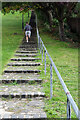
Running up Churchfields
There are just over 100 steps here so running up them requires a decent level of fitness.
Image: © Stephen McKay
Taken: 22 Oct 2021
0.03 miles
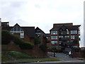
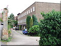
3
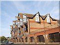
Apartments, The Esplanade
A modern riverside development.
Image: © N Chadwick
Taken: 15 Apr 2010
0.03 miles
6
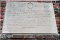
Churchfield Recreation Ground
This plaque is self-explanatory but what is curious is the way that two words have been deliberately but very crudely redacted. Close examination suggests they possibly read 'native city' which would make contextual sense. Rochester actually lost its city status in 1998 (apparently due to an oversight) but was certainly considered a city in 1906. In any case, why anyone should object to this wording is a mystery.
Image: © Stephen McKay
Taken: 22 Oct 2021
0.04 miles
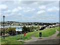
7
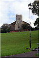
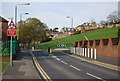
Churchfields
Churchfields is an open space occupying a steep bank above Rochester Esplanade. According to a nearby plaque it was presented to the City of Rochester by Councillor Charles Willis JP in 1906. It is overlooked by St Margaret's Church - a curious building that mostly dates from the mid-19th century but incorporates a much earlier tower thought to have been built around 1465.
Image: © Stephen McKay
Taken: 22 Oct 2021
0.05 miles
9
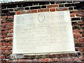
Commemorative plaque, Churchfields Recreation Ground, Rochester
Image: © Chris Whippet
Taken: 1 May 2015
0.05 miles